|
search place name
|
||
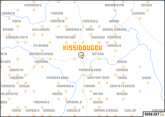
Kissidougou (Kissidougou, Guinea)Kissidougou is a town in the Kissidougou region of Guinea. An overview map of the region around Kissidougou is displayed below.
regional and 3d topo map of Kissidougou, Guinea ::
Kissidougou airports ::
The nearest airport is FAA - Faranah, located 119.5 km north west of Kissidougou.
Nearby towns ::
Songbo (1.8km west) //
Korodou (2.6km south east) //
Bondadou (2.6km south east) //
Seydou (3.7km east) //
Féro (3.7km south) //
Kérisané (3.7km north) //
Tamaniguédou (4.1km south east) //
Sokourala (4.1km north west) //
Kérédou (5.2km north east) //
Tambyandou (5.2km north west) //
Damendou (5.9km north) //
Mara (5.9km north) //
Kébéla (6.7km south east) //
Saint-Antonin (6.7km south east) //
Broadou (6.7km south east) //
Longoa (6.6km north east) //
Bouyé (7.4km south) //
Korendou (7.3km west) //
Sériadou (7.4km north) //
Camian (7.6km south) //
Kongola (7.5km east) //
Yomendou (7.6km north) //
Odossa (7.8km south east) //
Fermessadou (7.8km south west) //
Niamandou (8.3km south west) //
Kofodou (8.2km south east) //
Kénéma (8.3km north east) //
Tambyandou Koura (8.3km north west) //
Bayan (8.2km north east) //
[all distances 'as the bird flies' and approximate]  Places with similar names to Kissidougou, Guinea ::
Disclaimer :: Information on this page comes without warranty of any kind |
||
|
Where is Kissidougou? Elevation and coordinates ::
Latitude (lat): 9°11'0"N Longitude (lon): 10°6'0"W
Elevation (approx.): 527m (map arrows pan, magnifying glasses zoom) |
||
|
Visiting Kissidougou? Hotel/Accommodation ::
Book a hotel in Kissidougou Travel Guide ::
Buy a travel guide for Guinea rental cars ::
car rental offers GPS waypoint ::
download a GPX waypoint (PoI) of Kissidougou for your GPS receiver
|
||