|
search place name
|
||
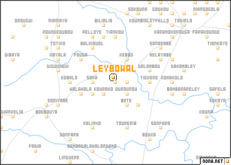
Ley Bowal (Dinguiraye, Guinea)Ley Bowal is a town in the Dinguiraye region of Guinea. An overview map of the region around Ley Bowal is displayed below.
regional and 3d topo map of Ley Bowal, Guinea ::
Ley Bowal airports ::
The nearest airport is FAA - Faranah, located 130.8 km south of Ley Bowal.
Other airports nearby include LEK - Labe (161.0 km west), KGG - Kedougou (214.2 km north west), Nearby towns ::
Pomaré (0.0km north) //
Bafilaté (1.8km east) //
Kourako (2.6km south west) //
Ourourou (2.6km south east) //
Soka (3.6km west) //
Vindikadioley (4.1km south west) //
Vindikadio (4.1km south west) //
Kebou (4.1km north east) //
Boté (4.1km south east) //
Bambadala (5.2km south east) //
Tiévéré (5.5km east) //
Dalambou (5.8km east) //
Walawala (5.8km west) //
Fouga (6.6km north west) //
Balkiouol (6.6km north west) //
Kobala (7.3km west) //
Tiankou (7.4km north) //
Maria (7.6km north) //
Toupéria (7.6km south) //
Pelloye (8.3km north west) //
Kalinko (8.3km south west) //
Helayabé (8.2km north east) //
Dalamado (8.2km north east) //
Sanarabé (9.2km north east) //
Sonfara (10.4km south east) //
[all distances 'as the bird flies' and approximate]  Places with similar names to Ley Bowal, Guinea ::
Disclaimer :: Information on this page comes without warranty of any kind |
||
|
Where is Ley Bowal? Elevation and coordinates ::
Latitude (lat): 11°13'0"N Longitude (lon): 10°49'0"W
Elevation (approx.): 406m (map arrows pan, magnifying glasses zoom) |
||
|
Visiting Ley Bowal? Hotel/Accommodation ::
Book a hotel in Ley Bowal Travel Guide ::
Buy a travel guide for Guinea rental cars ::
car rental offers GPS waypoint ::
download a GPX waypoint (PoI) of Ley Bowal for your GPS receiver
|
||