|
search place name
|
||
Sarabadou (Guékédou, Guinea)Sarabadou is a town in the Guékédou region of Guinea. An overview map of the region around Sarabadou is displayed below.
regional and 3d topo map of Sarabadou, Guinea ::

Sarabadou airports ::
The nearest airport is FAA - Faranah, located 148.5 km north of Sarabadou.
Nearby towns ::
Salé (2.1km north) //
Yarandou (2.1km west) //
Niolédou (2.4km south west) //
Foédou (2.5km south west) //
Singuedou (4.0km north west) //
Fongolo (4.5km north east) //
Kolifa (4.7km south west) //
Niéniédou (5.3km west) //
Kamian (5.3km west) //
Yourouadou (5.5km east) //
Kélebingo (5.5km east) //
Bingo (5.5km north) //
Sofédou (6.0km west) //
Yendé Louan (6.0km west) //
Kondobouillé (6.3km north east) //
Kolibenda (6.5km south east) //
Sofédou (7.0km north west) //
Kisene (7.0km south west) //
Nongoa (7.0km east) //
Maa (7.6km south east) //
Léobingo (7.6km west) //
Témessadou (7.9km north east) //
Kondobingo (7.9km north east) //
Tinndo (7.9km north) //
Ndema (7.9km west) //
Kadu (8.2km south west) //
Sandia (8.2km south west) //
Konoma (8.4km north west) //
Kombundu (8.6km south west) //
[all distances 'as the bird flies' and approximate] 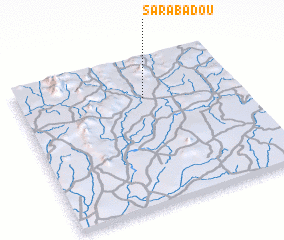 Places with similar names to Sarabadou, Guinea ::
Disclaimer :: Information on this page comes without warranty of any kind |
||
|
Where is Sarabadou? Elevation and coordinates ::
Latitude (lat): 8°44'8"N Longitude (lon): 10°25'51"W
Elevation (approx.): 422m (map arrows pan, magnifying glasses zoom) |
||
|
Visiting Sarabadou? Hotel/Accommodation ::
Book a hotel in Sarabadou Travel Guide ::
Buy a travel guide for Guinea rental cars ::
car rental offers GPS waypoint ::
download a GPX waypoint (PoI) of Sarabadou for your GPS receiver
|
||