|
search place name
|
||
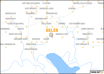
Séléa (Koundara, Guinea)Séléa is a town in the Koundara region of Guinea. An overview map of the region around Séléa is displayed below.
regional and 3d topo map of Séléa, Guinea ::
Séléa airports ::
The nearest airport is KGG - Kedougou, located 135.6 km east of Séléa.
Other airports nearby include TUD - Tambacounda (153.2 km north), LEK - Labe (171.2 km south east), Nearby towns ::
Saré Ambori (0.0km north) //
Altou (1.8km west) //
Labobandé (2.6km south west) //
Simdé (2.6km south west) //
Saré Alkèné (3.6km east) //
Orévenndou (3.7km north) //
Kangnéka (3.7km north) //
Linnkéré (4.1km south west) //
Voyloubé (4.1km north west) //
Kamabi (5.2km north east) //
Saré Abdoulaye (5.8km north) //
Gandiré (5.7km west) //
Oulandji (5.8km north) //
Gadalouguèl (6.6km north east) //
Saré Bourem (6.6km north west) //
Panoumpou (7.4km north) //
Bounta (7.2km east) //
Marou (7.6km north) //
Saré Dounia Sambassara (7.5km west) //
Nianougou (7.5km west) //
Saré Kébé (8.1km south west) //
Orévenndou (9.1km south west) //
Koumbaèl (10.4km north west) //
[all distances 'as the bird flies' and approximate]  Places with similar names to Séléa, Guinea ::
Disclaimer :: Information on this page comes without warranty of any kind |
||
|
Where is Séléa? Elevation and coordinates ::
Latitude (lat): 12°22'0"N Longitude (lon): 13°27'0"W
Elevation (approx.): 68m (map arrows pan, magnifying glasses zoom) |
||
|
Visiting Séléa? Hotel/Accommodation ::
Book a hotel in Séléa Travel Guide ::
Buy a travel guide for Guinea rental cars ::
car rental offers GPS waypoint ::
download a GPX waypoint (PoI) of Séléa for your GPS receiver
|
||