|
search place name
|
||
Childara ((( Kulyabskaya Oblast' )), Tajikistan)Childara is a town in the (( Kulyabskaya Oblast' )) region of Tajikistan. An overview map of the region around Childara is displayed below.
regional and 3d topo map of Childara, Tajikistan ::

Childara airports ::
The nearest airport is DYU - Dushanbe, located 131.5 km west of Childara.
Nearby towns ::
Pashor (1.8km west) //
Shakhob (2.8km north) //
Shŭri Poyon (2.5km east) //
Khamdora (6.2km south east) //
[all distances 'as the bird flies' and approximate] 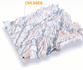 Places with similar names to Childara, Tajikistan ::
// Tioltiur (RO)
// Chellehdār (IR)
// Chelleh Darreh (IR)
// Shallow Water (US)
// Siāltāra (BD)
// Chauluturo (TP)
// Chaldar (KZ)
// Chul-Adyr (KZ)
// Shaldar (KZ)
// Shäūildir (KZ)
Disclaimer :: Information on this page comes without warranty of any kind |
||
|
Where is Childara? Elevation and coordinates ::
Latitude (lat): 38°47'5"N Longitude (lon): 70°18'17"E
Elevation (approx.): 1490m (map arrows pan, magnifying glasses zoom) |
||
|
Visiting Childara? Hotel/Accommodation ::
Book a hotel in Childara Travel Guide ::
Buy a travel guide for Tajikistan rental cars ::
car rental offers GPS waypoint ::
download a GPX waypoint (PoI) of Childara for your GPS receiver
|
||