|
search place name
|
||
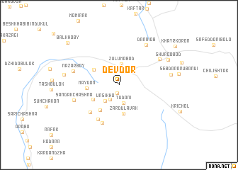
Devdor (Khatlon, Tajikistan)Devdor is a town in the Khatlon region of Tajikistan. An overview map of the region around Devdor is displayed below.
regional and 3d topo map of Devdor, Tajikistan ::
Devdor airports ::
The nearest airport is DYU - Dushanbe, located 130.2 km north west of Devdor.
Other airports nearby include UND - Kunduz Konduz (158.0 km south west), Nearby towns ::
Khishka-Sangou (1.3km south) //
Komsomolobod (2.4km north east) //
(( Kyshkasangou )) (2.6km south west) //
Tudani (2.9km south) //
(( Zulum-Abad )) (3.3km north) //
Ursikho (3.0km south west) //
Zardulavak (4.5km south) //
Bodomtu (4.0km north west) //
Urgaylak (4.0km south west) //
Korgaron (4.6km south west) //
(( Maydon )) (4.1km west) //
Khojabog (5.6km south west) //
Obitera (6.0km south west) //
Karagoch (6.3km south) //
Sangak-Chashma (6.1km south west) //
Nazarboy (6.1km west) //
Navabad (6.5km north east) //
Daraiob (7.2km north east) //
Sebdara-Kolon (6.7km east) //
Shŭroobod (7.3km north east) //
Dodrazak (7.0km west) //
Balkhoby (9.2km north west) //
[all distances 'as the bird flies' and approximate] 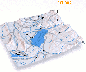 Places with similar names to Devdor, Tajikistan ::
Disclaimer :: Information on this page comes without warranty of any kind |
||
|
Where is Devdor? Elevation and coordinates ::
Latitude (lat): 37°48'15"N Longitude (lon): 69°58'46"E
Elevation (approx.): 1897m (map arrows pan, magnifying glasses zoom) |
||
|
Visiting Devdor? Hotel/Accommodation ::
Book a hotel in Devdor Travel Guide ::
Buy a travel guide for Tajikistan rental cars ::
car rental offers GPS waypoint ::
download a GPX waypoint (PoI) of Devdor for your GPS receiver
|
||