|
search place name
|
||
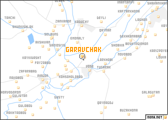
(( Garavchak )) (Khatlon, Tajikistan)(( Garavchak )) is a town in the Khatlon region of Tajikistan. An overview map of the region around (( Garavchak )) is displayed below.
regional and 3d topo map of (( Garavchak )), Tajikistan ::
(( Garavchak )) airports ::
The nearest airport is DYU - Dushanbe, located 106.8 km north west of (( Garavchak )).
Other airports nearby include UND - Kunduz Konduz (143.6 km south west), Nearby towns ::
Besharik (0.7km north) //
Vose' (2.5km south east) //
Gulobod (2.9km west) //
Mitin-Tugay (3.4km south west) //
Ėmomaly (4.2km north) //
Voseabadi-Kalon (3.6km west) //
Vose'obod (3.7km south west) //
Larkhobi (3.9km east) //
Tugarak (4.3km south east) //
Komsomolobod (5.1km south west) //
Komsomolobod (5.2km south west) //
(( Maroz )) (4.5km west) //
Sariosiyë (5.3km north west) //
Okchinor (5.6km south west) //
(( Kun-Tyube )) (6.9km south west) //
Qaynar (6.7km north east) //
Arpatuguldi (6.7km south west) //
Kaduchy (7.7km north) //
Shobika (6.4km east) //
Oqjar (6.7km west) //
Chukurak (7.5km north west) //
(( Sel'burg )) (7.6km north west) //
Zarkamor (8.6km north west) //
(( Deyli )) (9.1km north) //
Kulbek (8.5km north west) //
Qurbonshahid (8.3km south west) //
Zardolubog (9.1km north west) //
[all distances 'as the bird flies' and approximate] 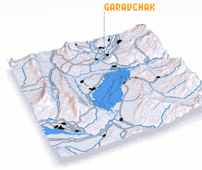 Places with similar names to (( Garavchak )), Tajikistan ::
Disclaimer :: Information on this page comes without warranty of any kind |
||
|
Where is (( Garavchak ))? Elevation and coordinates ::
Latitude (lat): 37°49'22"N Longitude (lon): 69°37'57"E
Elevation (approx.): 481m (map arrows pan, magnifying glasses zoom) |
||
|
Visiting (( Garavchak ))? Hotel/Accommodation ::
Book a hotel in (( Garavchak )) Travel Guide ::
Buy a travel guide for Tajikistan rental cars ::
car rental offers GPS waypoint ::
download a GPX waypoint (PoI) of (( Garavchak )) for your GPS receiver
|
||