|
search place name
|
||
Gulobod (Khatlon, Tajikistan)Gulobod is a town in the Khatlon region of Tajikistan. An overview map of the region around Gulobod is displayed below.
regional and 3d topo map of Gulobod, Tajikistan ::

Gulobod airports ::
The nearest airport is DYU - Dushanbe, located 109.4 km north west of Gulobod.
Other airports nearby include UND - Kunduz Konduz (129.0 km south west), Nearby towns ::
Novabad (1.7km south east) //
Pakhtaobod (2.2km south west) //
Gulistan (2.5km north west) //
Dashtigulo (2.8km south west) //
Mehnatobad (2.8km east) //
Chorvodoron (4.0km north west) //
Pakhtakor (4.5km south west) //
Arpatuguldy (4.1km north east) //
(( Atchanar )) (5.1km north) //
Uchastok Samanchi (4.7km west) //
(( Tysh-Tepe )) (5.8km north east) //
Gulistan (5.4km south east) //
Gulistan (5.1km east) //
Navobod (6.5km north) //
Fayzobod (6.5km south) //
Anjirkhon (6.8km south) //
Qurbonshahid (7.2km north east) //
Dŭsty (6.3km east) //
Zafarabad (7.8km north) //
(( Pingon )) (7.4km north east) //
Tagnob (7.7km south) //
Islomobod (7.2km south east) //
Kodara (8.0km south east) //
Daraikolot (7.9km south east) //
Arpatuguldi (8.6km north east) //
Okchinor (9.8km north east) //
[all distances 'as the bird flies' and approximate] 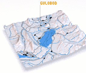 Places with similar names to Gulobod, Tajikistan ::
Disclaimer :: Information on this page comes without warranty of any kind |
||
|
Where is Gulobod? Elevation and coordinates ::
Latitude (lat): 37°43'21"N Longitude (lon): 69°30'54"E
Elevation (approx.): 465m (map arrows pan, magnifying glasses zoom) |
||
|
Visiting Gulobod? Hotel/Accommodation ::
Book a hotel in Gulobod Travel Guide ::
Buy a travel guide for Tajikistan rental cars ::
car rental offers GPS waypoint ::
download a GPX waypoint (PoI) of Gulobod for your GPS receiver
|
||