|
search place name
|
||
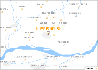
Kuybishevsk (Khatlon, Tajikistan)Kuybishevsk is a town in the Khatlon region of Tajikistan. An overview map of the region around Kuybishevsk is displayed below.
regional and 3d topo map of Kuybishevsk, Tajikistan ::
Kuybishevsk airports ::
The nearest airport is DYU - Dushanbe, located 65.9 km north of Kuybishevsk.
Other airports nearby include UND - Kunduz Konduz (142.8 km south), MZR - Mazar-i-sharif Mazar I Sharif (198.3 km south west), SKD - Samarkand (251.2 km north west), Nearby towns ::
Rokhi Sotsializm (1.5km east) //
Tut (4.0km north) //
Uchkun (4.0km north) //
Aral (6.0km north) //
Navdi (6.6km north) //
Akmazar (5.7km north east) //
Imeni Chapayeva (5.7km south east) //
Yavanabad (5.7km south east) //
Khodzhakala (6.9km north) //
Lenin Yuly (6.9km north) //
Ozodii Shark (6.8km north east) //
Molotovabad (7.4km north) //
Leninabad (5.8km west) //
Sverdlov (7.0km north west) //
Yakkatut (6.1km west) //
[all distances 'as the bird flies' and approximate] 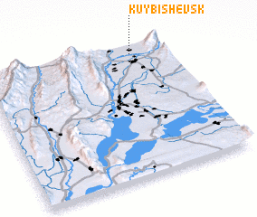 Places with similar names to Kuybishevsk, Tajikistan ::
// Kuybyshevskiy (RU)
// Kuybyshevskiy (RU)
// Kuybyshevskiy (RU)
// Kuybyshevskiy (KZ)
// Kūybyshevskīy (KZ)
// Kūybyshevskoe (KZ)
// Kuybishevskiy (TJ)
// Kuybyshevs'ke (UA)
// Kuybyshevskiy (KZ)
// Kuybyshevskiy (RU)
Disclaimer :: Information on this page comes without warranty of any kind |
||
|
Where is Kuybishevsk? Elevation and coordinates ::
Latitude (lat): 37°57'0"N Longitude (lon): 68°49'0"E
Elevation (approx.): 425m (map arrows pan, magnifying glasses zoom) |
||
|
Visiting Kuybishevsk? Hotel/Accommodation ::
Book a hotel in Kuybishevsk Travel Guide ::
Buy a travel guide for Tajikistan rental cars ::
car rental offers GPS waypoint ::
download a GPX waypoint (PoI) of Kuybishevsk for your GPS receiver
|
||