|
search place name
|
||
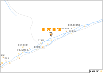
Murgudga ((( Kulyabskaya Oblast' )), Tajikistan)Murgudga is a town in the (( Kulyabskaya Oblast' )) region of Tajikistan. An overview map of the region around Murgudga is displayed below.
regional and 3d topo map of Murgudga, Tajikistan ::
Murgudga airports ::
The nearest airport is OSS - Osh, located 235.0 km north of Murgudga.
Nearby towns ::
Garmchashma (1.4km south) //
Rovand (3.1km south) //
Starg (3.7km south west) //
Lyangar (4.4km south west) //
Yazgo (4.9km south west) //
Vanvan Poyon (4.7km north east) //
Gumas (6.2km south west) //
Sumgad (6.0km east) //
Vanvan-Bolo (7.3km north east) //
Dursher (7.7km south west) //
[all distances 'as the bird flies' and approximate] 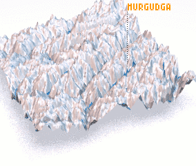 Places with similar names to Murgudga, Tajikistan ::
Disclaimer :: Information on this page comes without warranty of any kind |
||
|
Where is Murgudga? Elevation and coordinates ::
Latitude (lat): 38°37'9"N Longitude (lon): 71°51'33"E
Elevation (approx.): 2222m (map arrows pan, magnifying glasses zoom) |
||
|
Visiting Murgudga? Hotel/Accommodation ::
Book a hotel in Murgudga Travel Guide ::
Buy a travel guide for Tajikistan rental cars ::
car rental offers GPS waypoint ::
download a GPX waypoint (PoI) of Murgudga for your GPS receiver
|
||