|
search place name
|
||
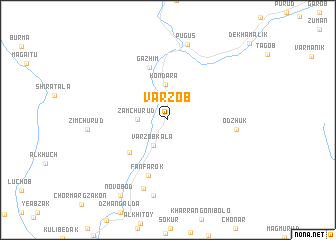
Varzob ((( Kulyabskaya Oblast' )), Tajikistan)Varzob is a town in the (( Kulyabskaya Oblast' )) region of Tajikistan. An overview map of the region around Varzob is displayed below.
regional and 3d topo map of Varzob, Tajikistan ::
Varzob airports ::
The nearest airport is DYU - Dushanbe, located 25.8 km south of Varzob.
Other airports nearby include SKD - Samarkand (189.6 km north west), Nearby towns ::
Begar (3.0km north west) //
Varzobkala (3.1km south west) //
Zamchurud (2.7km west) //
Kondara (4.0km north) //
Guskharf (4.9km south west) //
Gazhim (6.1km north) //
Fanfarok (6.4km south) //
Odzhuk (6.1km east) //
Firŭzoobod (8.0km south) //
Sharshara (8.5km south) //
Pugus (8.6km north) //
Novobod (9.4km south west) //
Dagana (9.4km south west) //
[all distances 'as the bird flies' and approximate] 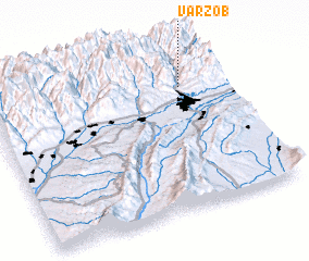 Places with similar names to Varzob, Tajikistan ::
Disclaimer :: Information on this page comes without warranty of any kind |
||
|
Where is Varzob? Elevation and coordinates ::
Latitude (lat): 38°46'33"N Longitude (lon): 68°49'51"E
Elevation (approx.): 1315m (map arrows pan, magnifying glasses zoom) |
||
|
Visiting Varzob? Hotel/Accommodation ::
Book a hotel in Varzob Travel Guide ::
Buy a travel guide for Tajikistan rental cars ::
car rental offers GPS waypoint ::
download a GPX waypoint (PoI) of Varzob for your GPS receiver
|
||