|
search place name
|
||
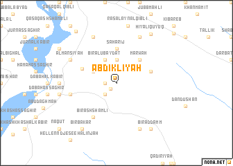
‘Abdiklīyah (Ḩalab, Syria)‘Abdiklīyah is a town in the Ḩalab region of Syria. An overview map of the region around ‘Abdiklīyah is displayed below.
regional and 3d topo map of ‘Abdiklīyah, Syria ::
‘Abdiklīyah airports ::
The nearest airport is GZT - Gaziantep Oguzeli, located 95.6 km north west of ‘Abdiklīyah.
Other airports nearby include ALP - Aleppo Intl (107.4 km west), DEZ - Deire Zor Deir Zzor (209.5 km south east), PMS - Palmyra (211.9 km south), MLX - Malatya Erhac (219.9 km north), Nearby towns ::
Khānūnīyah (1.2km south west) //
Khātūnīyah (1.5km west) //
Biʼr Ḑahr al Faraj (2.4km south west) //
Ţūbā (3.7km north) //
Biʼr al ‘Ubaydāt (4.0km north) //
Al Muwayliḩ (3.5km north west) //
Marwaḩ (4.8km north east) //
Şahārīj (5.6km north) //
Khirbat Zarbah (4.8km north east) //
Sufayţah (5.0km north west) //
Biʼr ash Shamlī (6.3km south west) //
Tall Bawāt (6.2km west) //
Ḩyālī Kūyuk (8.0km north) //
Maghāratayn (8.0km north) //
Maḩfāz̧ah (8.0km south) //
Ḩafyān (7.0km north west) //
Al Mansīyah (7.0km north west) //
Biʼr ad Damm (8.7km south east) //
Biʼr Bakâr (8.7km south west) //
Ḩiyālī Qūyūq (9.1km north east) //
Milḩah (9.8km north west) //
[all distances 'as the bird flies' and approximate] 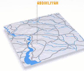 Places with similar names to ‘Abdiklīyah, Syria :: Disclaimer :: Information on this page comes without warranty of any kind |
||
|
Where is ‘Abdiklīyah? Elevation and coordinates ::
Latitude (lat): 36°28'0"N Longitude (lon): 38°22'0"E
Elevation (approx.): 393m (map arrows pan, magnifying glasses zoom) |
||
|
Visiting ‘Abdiklīyah? Hotel/Accommodation ::
Book a hotel in ‘Abdiklīyah Travel Guide ::
Buy a travel guide for Syria rental cars ::
car rental offers GPS waypoint ::
download a GPX waypoint (PoI) of ‘Abdiklīyah for your GPS receiver
|
||