|
search place name
|
||
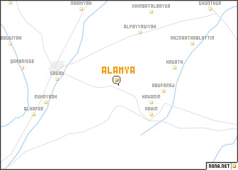
Al ‘Amyā (Ḩimş, Syria)Al ‘Amyā is a town in the Ḩimş region of Syria. An overview map of the region around Al ‘Amyā is displayed below.
regional and 3d topo map of Al ‘Amyā, Syria ::
Al ‘Amyā airports ::
The nearest airport is DAM - Damascus Intl, located 108.4 km south west of Al ‘Amyā.
Other airports nearby include PMS - Palmyra (122.7 km east), BEY - Beirut Rafic Hariri Intl (150.8 km west), LTK - Latakia Bassel Al Assad Intl (157.4 km north west), RPN - Rosh Pina Mahanaim I Ben Yaakov (198.0 km south west), Nearby towns ::
Ḩawārīn (5.0km south east) //
Mahīn (6.3km south east) //
Abū Faraj (5.8km east) //
Al Fayyāḑīyah (8.8km north) //
Ḩadath (7.8km east) //
[all distances 'as the bird flies' and approximate] 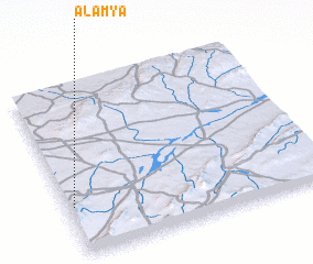 Places with similar names to Al ‘Amyā, Syria ::
// Almaya (MX)
// Al Māyah (LY)
// Alimaya (GN)
// Al ‘Amīyah (SY)
// Al ‘Awwāmīyah (SY)
// Al ‘Awwāmīyah (EG)
// Al Māʼīyah (TN)
// ‘Alemaya (ET)
// Al ‘Amyāʼ (SY)
// ‘Alem Maya (ET)
Disclaimer :: Information on this page comes without warranty of any kind |
||
|
Where is Al ‘Amyā? Elevation and coordinates ::
Latitude (lat): 34°17'30"N Longitude (lon): 37°1'15"E
Elevation (approx.): 881m (map arrows pan, magnifying glasses zoom) |
||
|
Visiting Al ‘Amyā? Hotel/Accommodation ::
Book a hotel in Al ‘Amyā Travel Guide ::
Buy a travel guide for Syria rental cars ::
car rental offers GPS waypoint ::
download a GPX waypoint (PoI) of Al ‘Amyā for your GPS receiver
|
||