|
search place name
|
||
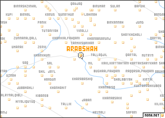
‘Arabshāh (Ḩalab, Syria)‘Arabshāh is a town in the Ḩalab region of Syria. An overview map of the region around ‘Arabshāh is displayed below.
regional and 3d topo map of ‘Arabshāh, Syria ::
‘Arabshāh airports ::
The nearest airport is GZT - Gaziantep Oguzeli, located 100.4 km west of ‘Arabshāh.
Other airports nearby include ALP - Aleppo Intl (127.7 km south west), DIY - Diyabakir Diyarbakir (203.6 km north east), MLX - Malatya Erhac (203.8 km north), DEZ - Deire Zor Deir Zzor (210.5 km south east), Nearby towns ::
Khānīk at Taḩtānī (1.5km west) //
Mīl (2.4km south east) //
Tirmīk Shaykhān (2.4km north west) //
Tarmīk Shīkhān (2.8km north) //
Tall Āqjil (3.0km east) //
Khānīk al Fawqānī (4.8km north west) //
Kharāb Şārūnj (4.8km north east) //
Kūbār Mutayyaf (5.6km south) //
Kharāb ‘Āshiq (5.6km south) //
Yīrāllī (5.6km north) //
Mandik (4.8km south west) //
Dībrak Shaykhān (5.8km north) //
Bughā al Fawqānī (5.8km south east) //
Kaklīk al Fawqānī (5.9km east) //
Bawz Huyūk at Taḩtānī (7.4km north) //
Şal (6.2km west) //
Kaklīk at Taḩtānī (6.2km east) //
Bawz Huyūk al Fawqānī (7.6km north) //
Bawz Huyūk al Fawqānī (7.6km north) //
Dār as Salām (7.6km north) //
Bughā at Taḩtānī (7.1km south east) //
Jayl (6.7km south west) //
Shaykh Qamaz (6.9km south east) //
Kawjak (8.0km north) //
Darflīt (8.0km south) //
Qāzānī at Fawqānī (7.0km south east) //
Ash Shaykh Qamar (7.0km south east) //
Kallat al Kabīr (7.0km north east) //
Tall al Aghbar Fawqānī (8.4km north) //
[all distances 'as the bird flies' and approximate] 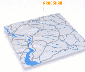 Places with similar names to ‘Arabshāh, Syria ::
Disclaimer :: Information on this page comes without warranty of any kind |
||
|
Where is ‘Arabshāh? Elevation and coordinates ::
Latitude (lat): 36°38'0"N Longitude (lon): 38°32'0"E
Elevation (approx.): 521m (map arrows pan, magnifying glasses zoom) |
||
|
Visiting ‘Arabshāh? Hotel/Accommodation ::
Book a hotel in ‘Arabshāh Travel Guide ::
Buy a travel guide for Syria rental cars ::
car rental offers GPS waypoint ::
download a GPX waypoint (PoI) of ‘Arabshāh for your GPS receiver
|
||