|
search place name
|
||
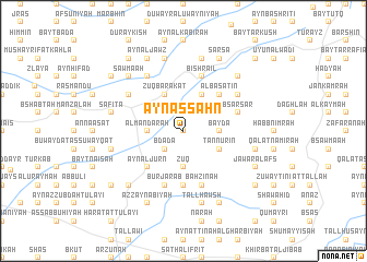
‘Ayn aş Şaḩn (Ţarţūs, Syria)‘Ayn aş Şaḩn is a town in the Ţarţūs region of Syria. An overview map of the region around ‘Ayn aş Şaḩn is displayed below.
regional and 3d topo map of ‘Ayn aş Şaḩn, Syria ::
‘Ayn aş Şaḩn airports ::
The nearest airport is LTK - Latakia Bassel Al Assad Intl, located 70.0 km north of ‘Ayn aş Şaḩn.
Other airports nearby include BEY - Beirut Rafic Hariri Intl (126.0 km south west), DAM - Damascus Intl (157.1 km south), ALP - Aleppo Intl (180.0 km north east), RPN - Rosh Pina Mahanaim I Ben Yaakov (209.5 km south), Nearby towns ::
Duraykīsh Zurayb (0.0km north) //
Bdādā (2.4km south west) //
Marj Dhubāb (2.4km north west) //
Zūq (3.7km south) //
Nab‘ al ‘Arūs (3.7km south) //
Al Mandarah (3.0km west) //
Ḑahr al Bayāţirah (3.0km west) //
Bayḑāʼ (3.0km east) //
‘Ayn ar Rayḩānah (3.0km east) //
Zūq Barakāt (4.0km north) //
Bţārish (4.0km north) //
Ḩūḩū (3.6km north west) //
Tannūrīn (3.6km south east) //
Barqīyah (3.6km south east) //
Bayt Aşlān (3.6km north east) //
As Sīsnīyah (4.8km south west) //
‘Ayn al Jurn (4.8km south west) //
Al Basātīn (4.8km north east) //
Bālū (4.8km north east) //
Jubb al Amlas (5.6km south) //
Burj ‘Arab (5.8km south) //
Bşarşar (4.9km east) //
Baḩzīnah (5.8km south) //
Bishrāʼīl (5.8km north) //
Nab‘ Karkar (5.9km north east) //
Duwayr al Mallū‘ā (5.9km north east) //
Al Bāriqīyah (5.9km north east) //
Karm Mughayzil (6.3km north west) //
As Suwaydah (5.9km north west) //
[all distances 'as the bird flies' and approximate]  Places with similar names to ‘Ayn aş Şaḩn, Syria ::
Disclaimer :: Information on this page comes without warranty of any kind |
||
|
Where is ‘Ayn aş Şaḩn? Elevation and coordinates ::
Latitude (lat): 34°48'0"N Longitude (lon): 36°11'0"E
Elevation (approx.): 219m (map arrows pan, magnifying glasses zoom) |
||
|
Visiting ‘Ayn aş Şaḩn? Hotel/Accommodation ::
Book a hotel in ‘Ayn aş Şaḩn Travel Guide ::
Buy a travel guide for Syria rental cars ::
car rental offers GPS waypoint ::
download a GPX waypoint (PoI) of ‘Ayn aş Şaḩn for your GPS receiver
|
||