|
search place name
|
||
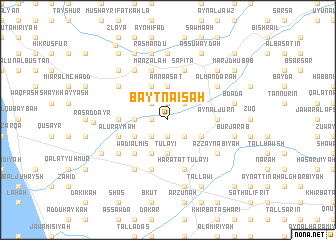
Bayt Nā‘isah (Ţarţūs, Syria)Bayt Nā‘isah is a town in the Ţarţūs region of Syria. An overview map of the region around Bayt Nā‘isah is displayed below.
regional and 3d topo map of Bayt Nā‘isah, Syria ::
Bayt Nā‘isah airports ::
The nearest airport is LTK - Latakia Bassel Al Assad Intl, located 71.7 km north of Bayt Nā‘isah.
Other airports nearby include BEY - Beirut Rafic Hariri Intl (119.1 km south west), DAM - Damascus Intl (155.2 km south), ALP - Aleppo Intl (187.1 km north east), RPN - Rosh Pina Mahanaim I Ben Yaakov (204.0 km south), Nearby towns ::
Bayt ash Shaykh Yūnus (1.9km north) //
Al Hirmil (1.9km south) //
At Tawānīn (1.5km west) //
Buwayḑat as Suwayqāt (2.4km north west) //
Al Kanīsah (2.4km north east) //
Ḑahr Bashīr (2.4km south west) //
Yāzidīyat Ḩamdān (2.4km south east) //
‘Abbūlī (2.4km south west) //
An Na‘āşāt (3.7km north) //
Muwaysinah (3.0km west) //
Tall al Khiḑr (3.7km south) //
Ţulay‘ī (3.7km south) //
Jūrat ash Shanbūr (4.0km north) //
Ḩikr Jubb al Amlas (3.6km south east) //
‘Abbūlī ‘Arīḑ (3.6km south west) //
Nāḩūt (4.0km south) //
Duwayr aţ Ţulay‘ī (4.0km south) //
Wādī al Mīs (4.8km south west) //
‘Ayn az Zubdah (4.8km south west) //
As Sīsnīyah (4.6km east) //
‘Ayn al Jurn (4.6km east) //
Turkab (4.6km west) //
Şāfītā (5.8km north) //
Manzalah (5.8km north) //
Tall Turmus (5.8km south) //
Ḩārat aţ Ţulay‘ī (5.8km south) //
Al ‘Uraymah (4.9km west) //
Kafr Fū (5.8km south) //
Al Mandarah (5.9km north east) //
[all distances 'as the bird flies' and approximate]  Places with similar names to Bayt Nā‘isah, Syria ::
Disclaimer :: Information on this page comes without warranty of any kind |
||
|
Where is Bayt Nā‘isah? Elevation and coordinates ::
Latitude (lat): 34°46'0"N Longitude (lon): 36°6'0"E
Elevation (approx.): 111m (map arrows pan, magnifying glasses zoom) |
||
|
Visiting Bayt Nā‘isah? Hotel/Accommodation ::
Book a hotel in Bayt Nā‘isah Travel Guide ::
Buy a travel guide for Syria rental cars ::
car rental offers GPS waypoint ::
download a GPX waypoint (PoI) of Bayt Nā‘isah for your GPS receiver
|
||