|
search place name
|
||
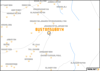
Bustān Şubayḩ (Ḩimş, Syria)Bustān Şubayḩ is a town in the Ḩimş region of Syria. An overview map of the region around Bustān Şubayḩ is displayed below.
regional and 3d topo map of Bustān Şubayḩ, Syria ::
Bustān Şubayḩ airports ::
The nearest airport is PMS - Palmyra, located 81.9 km south east of Bustān Şubayḩ.
Other airports nearby include ALP - Aleppo Intl (139.5 km north), LTK - Latakia Bassel Al Assad Intl (155.1 km west), DAM - Damascus Intl (196.6 km south west), GZT - Gaziantep Oguzeli (221.3 km north), Nearby towns ::
Jawwāşīyat al Janūbīyah (3.4km north east) //
Al Makhbūţah (3.7km west) //
Jawwāşīyat ash Shamālīyah (4.8km north) //
Al Lujj (5.9km south west) //
Jubb ar Rayyān (5.8km west) //
Umm Qubaybah (7.0km south) //
Ma‘ḑamīyah (6.5km north west) //
Khirbat Sinnū al Fāḑil (8.3km south) //
Tall Shihāb (7.8km south west) //
Al Mushayrifah (8.7km north west) //
Al Jurf ash Shamālī (9.0km south west) //
Al Jurf al Janūbī (9.9km south west) //
Ghazālah (10.7km south west) //
[all distances 'as the bird flies' and approximate]  Places with similar names to Bustān Şubayḩ, Syria :: Disclaimer :: Information on this page comes without warranty of any kind |
||
|
Where is Bustān Şubayḩ? Elevation and coordinates ::
Latitude (lat): 34°57'15"N Longitude (lon): 37°33'45"E
Elevation (approx.): 773m (map arrows pan, magnifying glasses zoom) |
||
|
Visiting Bustān Şubayḩ? Hotel/Accommodation ::
Book a hotel in Bustān Şubayḩ Travel Guide ::
Buy a travel guide for Syria rental cars ::
car rental offers GPS waypoint ::
download a GPX waypoint (PoI) of Bustān Şubayḩ for your GPS receiver
|
||