|
search place name
|
||
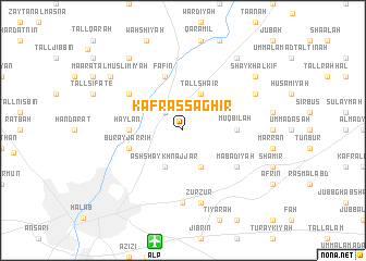
Kafr aş Şaghīr (Ḩalab, Syria)Kafr aş Şaghīr is a town in the Ḩalab region of Syria. An overview map of the region around Kafr aş Şaghīr is displayed below.
regional and 3d topo map of Kafr aş Şaghīr, Syria ::
Kafr aş Şaghīr airports ::
The nearest airport is ALP - Aleppo Intl, located 11.6 km south of Kafr aş Şaghīr.
Other airports nearby include GZT - Gaziantep Oguzeli (76.5 km north), LTK - Latakia Bassel Al Assad Intl (153.0 km south west), ADA - Adana Incirlik Ab (181.6 km north west), ADA - Adana (192.5 km north west), Nearby towns ::
Bābinnis (2.4km north west) //
Ash Shaykh Najjār (4.0km south) //
Ash Shaykh Zayyāt (4.0km south) //
Tall Sha‘īr (4.0km north) //
Muqbilah (4.5km east) //
Ḩaylān (4.5km west) //
Burayj ar Rīḩ (4.9km west) //
Fāfīn (5.8km north) //
Ma‘badīyah (5.8km south east) //
Muslimīyah (5.8km north west) //
Naqqārīn (7.4km south) //
Zurzūr (7.6km south) //
Dayr Ḩanţā (7.0km north east) //
Shaykh al Kīf (8.2km north east) //
Ma‘ārat al Muslimīyah (8.2km north west) //
Kafr Qāriş (8.7km north west) //
Ḩalīsah (8.7km north east) //
[all distances 'as the bird flies' and approximate]  Places with similar names to Kafr aş Şaghīr, Syria ::
// Kafr Şafrāʼ (SY)
Disclaimer :: Information on this page comes without warranty of any kind |
||
|
Where is Kafr aş Şaghīr? Elevation and coordinates ::
Latitude (lat): 36°17'0"N Longitude (lon): 37°15'0"E
Elevation (approx.): 500m (map arrows pan, magnifying glasses zoom) |
||
|
Visiting Kafr aş Şaghīr? Hotel/Accommodation ::
Book a hotel in Kafr aş Şaghīr Travel Guide ::
Buy a travel guide for Syria rental cars ::
car rental offers GPS waypoint ::
download a GPX waypoint (PoI) of Kafr aş Şaghīr for your GPS receiver
|
||