|
search place name
|
||
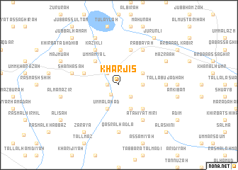
Kharjīs (Ḩalab, Syria)Kharjīs is a town in the Ḩalab region of Syria. An overview map of the region around Kharjīs is displayed below.
regional and 3d topo map of Kharjīs, Syria ::
Kharjīs airports ::
The nearest airport is ALP - Aleppo Intl, located 55.9 km west of Kharjīs.
Other airports nearby include GZT - Gaziantep Oguzeli (80.2 km north west), LTK - Latakia Bassel Al Assad Intl (196.4 km south west), PMS - Palmyra (196.5 km south), Nearby towns ::
Abū Jurayn (1.5km west) //
Jannāt Abū Jidḩah (1.8km south west) //
Abū Ţawīl (2.4km north west) //
Tall Jadhah (2.4km south east) //
Jannāt aş Şaghīr (3.0km east) //
Umm al ‘Amad (4.0km south) //
Abū Jadhah ‘Atīq (4.0km south) //
Jannāt as Salāmah (3.5km north east) //
Umm Amyāl (4.8km north west) //
Abū Jadhah Kubrá (4.8km south east) //
Raḩmānīyah (4.8km west) //
Abū Khaţţār (5.8km north) //
Kāziklī (6.3km north west) //
Rabbāyah (6.3km north east) //
‘Atawīyat Mīrī (6.3km south east) //
Qaşr al Hadlāʼ (7.4km south) //
Tall Abū Jadhah (6.0km east) //
Shanhaşah (6.3km west) //
Ḩalīsīyah (8.0km north) //
Mazra‘ah (7.0km north east) //
Za‘rāyā (8.7km south west) //
Ḩaymar al Jays (8.7km north east) //
Jūrunlī (8.7km north east) //
Jubb al Ḩamām (9.5km north west) //
Al ‘Ashīnī (9.5km south east) //
[all distances 'as the bird flies' and approximate]  Places with similar names to Kharjīs, Syria :: Disclaimer :: Information on this page comes without warranty of any kind |
||
|
Where is Kharjīs? Elevation and coordinates ::
Latitude (lat): 36°17'0"N Longitude (lon): 37°50'0"E
Elevation (approx.): 420m (map arrows pan, magnifying glasses zoom) |
||
|
Visiting Kharjīs? Hotel/Accommodation ::
Book a hotel in Kharjīs Travel Guide ::
Buy a travel guide for Syria rental cars ::
car rental offers GPS waypoint ::
download a GPX waypoint (PoI) of Kharjīs for your GPS receiver
|
||