|
search place name
|
||
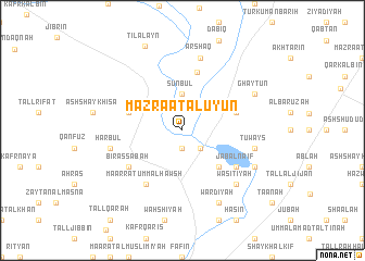
Mazra‘at al ‘Uyūn (Ḩalab, Syria)Mazra‘at al ‘Uyūn is a town in the Ḩalab region of Syria. An overview map of the region around Mazra‘at al ‘Uyūn is displayed below.
regional and 3d topo map of Mazra‘at al ‘Uyūn, Syria ::
Mazra‘at al ‘Uyūn airports ::
The nearest airport is ALP - Aleppo Intl, located 29.9 km south of Mazra‘at al ‘Uyūn.
Other airports nearby include GZT - Gaziantep Oguzeli (59.4 km north), LTK - Latakia Bassel Al Assad Intl (164.3 km south west), ADA - Adana Incirlik Ab (172.7 km west), ADA - Adana (184.2 km west), Nearby towns ::
Tall Mālid (1.9km south) //
Jisr as Samūqah (2.4km south east) //
Sunbul (3.7km north) //
Qawl Surūj (4.8km south east) //
Māri‘ (4.8km north west) //
Ghūz (4.8km north east) //
Ḩawār an Nahr (6.1km north) //
Biʼr aş Şabāḩ (5.8km south west) //
Ma‘arrat Umm al Ḩawsh (6.3km south west) //
Jabal Nāʼif (5.8km south east) //
Ḩarbul (6.2km west) //
Arshāq (7.6km north) //
Tuways (6.2km east) //
Wāsiţīyah (7.1km south east) //
Ghayţūn (7.0km north east) //
Kassār (7.0km south east) //
Wardīyah (8.0km south) //
Tilālayn (9.1km north) //
[all distances 'as the bird flies' and approximate]  Places with similar names to Mazra‘at al ‘Uyūn, Syria :: Disclaimer :: Information on this page comes without warranty of any kind |
||
|
Where is Mazra‘at al ‘Uyūn? Elevation and coordinates ::
Latitude (lat): 36°27'0"N Longitude (lon): 37°14'0"E
Elevation (approx.): 438m (map arrows pan, magnifying glasses zoom) |
||
|
Visiting Mazra‘at al ‘Uyūn? Hotel/Accommodation ::
Book a hotel in Mazra‘at al ‘Uyūn Travel Guide ::
Buy a travel guide for Syria rental cars ::
car rental offers GPS waypoint ::
download a GPX waypoint (PoI) of Mazra‘at al ‘Uyūn for your GPS receiver
|
||