|
search place name
|
||
Al Maksūrīyah (Musandam, Oman)Al Maksūrīyah is a town in the Musandam region of Oman. An overview map of the region around Al Maksūrīyah is displayed below.
regional and 3d topo map of Al Maksūrīyah, Oman ::

Al Maksūrīyah airports ::
The nearest airport is KHS - Khasab, located 30.5 km north west of Al Maksūrīyah.
Other airports nearby include RKT - Ras Al Khaimah Intl (60.1 km south west), FJR - Fujeirah Fujairah Intl (92.6 km south), SHJ - Sharjah Intl (112.9 km south west), DXB - Dubai Intl (130.3 km south west), Nearby towns ::
Līmā (1.2km east) //
Al ‘Aqabah (1.4km south) //
Daynī (1.5km south west) //
Māwī (3.1km north west) //
Ad Duss (4.5km south west) //
Al Khawīyah (6.7km north west) //
Al Khaţmah (7.8km north) //
Suwayah (9.3km north) //
Al Ghalīl (9.1km south west) //
Khaţm Kabīr (10.9km south west) //
[all distances 'as the bird flies' and approximate] 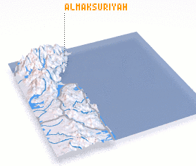 Places with similar names to Al Maksūrīyah, Oman :: Disclaimer :: Information on this page comes without warranty of any kind |
||
|
Where is Al Maksūrīyah? Elevation and coordinates ::
Latitude (lat): 25°56'39"N Longitude (lon): 56°24'48"E
Elevation (approx.): 7m (map arrows pan, magnifying glasses zoom) |
||
|
Visiting Al Maksūrīyah? Hotel/Accommodation ::
Book a hotel in Al Maksūrīyah Travel Guide ::
Buy a travel guide for Oman rental cars ::
car rental offers GPS waypoint ::
download a GPX waypoint (PoI) of Al Maksūrīyah for your GPS receiver
|
||