|
search place name
|
||
Akoko (Gongola, Nigeria)Akoko is a town in the Gongola region of Nigeria. An overview map of the region around Akoko is displayed below.
regional and 3d topo map of Akoko, Nigeria ::

Akoko airports ::
The nearest airport is COO - Cotonou Cadjehoun, located 39.5 km west of Akoko.
Other airports nearby include LOS - Lagos Murtala Muhammed (66.9 km east), LFW - Lome Gnassingbe Eyadema Intl (166.3 km west), IBA - Ibadan (171.7 km north east), Nearby towns ::
Kweme (1.9km south) //
Whekan (1.9km north) //
Ganme (2.6km south west) //
Pasi (2.6km north west) //
Kese (3.7km east) //
Ahanfe (3.7km east) //
Wesere (4.1km south east) //
Soke (5.2km north east) //
Ropoji (5.8km east) //
Igbogbele (5.8km east) //
Ijomi (5.9km north) //
Ilepa (5.9km north) //
Dja (7.4km west) //
Gbodo (7.4km north) //
Angorin (7.6km east) //
Ijofin (7.6km north) //
Agada (7.8km north east) //
Akraké (8.2km south west) //
Afanji (8.3km north east) //
Sèdjé (9.2km north west) //
Igude (9.2km north east) //
Maguta (9.2km north east) //
Dangbo (9.2km north west) //
Osibadan (9.2km north east) //
Bahica (10.5km north west) //
[all distances 'as the bird flies' and approximate] 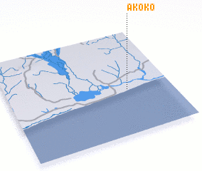 Places with similar names to Akoko, Nigeria ::
Disclaimer :: Information on this page comes without warranty of any kind |
||
|
Where is Akoko? Elevation and coordinates ::
Latitude (lat): 6°26'0"N Longitude (lon): 2°44'0"E
Elevation (approx.): 7m (map arrows pan, magnifying glasses zoom) |
||
|
Visiting Akoko? Hotel/Accommodation ::
Book a hotel in Akoko Travel Guide ::
Buy a travel guide for Nigeria rental cars ::
car rental offers GPS waypoint ::
download a GPX waypoint (PoI) of Akoko for your GPS receiver
|
||