|
search place name
|
||
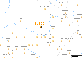
Busogmi (Gongola, Nigeria)Busogmi is a town in the Gongola region of Nigeria. An overview map of the region around Busogmi is displayed below.
regional and 3d topo map of Busogmi, Nigeria ::
Busogmi airports ::
The nearest airport is MXJ - Minna New, located 49.8 km west of Busogmi.
Other airports nearby include ABV - Abuja Nnamdi Azikiwe Intl (70.6 km south east), KAD - Kaduna (136.6 km north), ZAR - Zaria (196.5 km north east), JOS - Jos Yakubu Gowon (216.5 km east), Nearby towns ::
Sofon Gbusumi (3.7km south) //
Dirri (4.1km south east) //
Gbusumi (4.1km south west) //
Kpewi (5.5km east) //
Wodna (6.6km south east) //
Sheuda (7.6km south) //
Nadna (7.8km north east) //
Napadna (7.8km south east) //
Geji (8.3km south east) //
Pita (8.3km south west) //
Rotafi (8.2km south west) //
Zuru (9.2km south west) //
[all distances 'as the bird flies' and approximate] 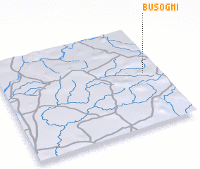 Places with similar names to Busogmi, Nigeria ::
// Bosokamo (CD)
// Bauschheim (DE)
// Bischheim (DE)
// Bascom (US)
// Bascom (US)
// Bascom (US)
// Bascom (US)
// Bascom (US)
// Bascom (US)
// Boussikomi (BF)
Disclaimer :: Information on this page comes without warranty of any kind |
||
|
Where is Busogmi? Elevation and coordinates ::
Latitude (lat): 9°32'0"N Longitude (lon): 6°54'0"E
Elevation (approx.): 363m (map arrows pan, magnifying glasses zoom) |
||
|
Visiting Busogmi? Hotel/Accommodation ::
Book a hotel in Busogmi Travel Guide ::
Buy a travel guide for Nigeria rental cars ::
car rental offers GPS waypoint ::
download a GPX waypoint (PoI) of Busogmi for your GPS receiver
|
||