|
search place name
|
||
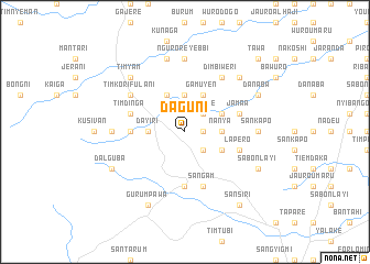
Daguni (Gongola, Nigeria)Daguni is a town in the Gongola region of Nigeria. An overview map of the region around Daguni is displayed below.
regional and 3d topo map of Daguni, Nigeria ::
Daguni airports ::
The nearest airport is YOL - Yola, located 96.5 km north east of Daguni.
Other airports nearby include GOU - Garoua (179.0 km north east), NGE - N'gaoundere Ngaoundere (217.4 km south east), Nearby towns ::
Gangreni (1.8km east) //
Timdore (2.6km north east) //
Yelwa (2.6km south east) //
Bankureni (3.7km north) //
Buweti (3.7km north) //
Nanya (3.7km east) //
Dayiri (3.7km west) //
Kuvani (4.1km north east) //
Gamuyen (4.1km north east) //
Gangbugeni (4.1km south east) //
Nagana (4.1km north west) //
Gangjomen (5.5km west) //
Numvan (5.6km south) //
Jarendi (5.8km west) //
Timdinga (5.8km west) //
Sangam (5.9km south) //
Jamaa (5.8km east) //
Lapero (5.8km east) //
Gangwoni (6.6km north west) //
Timkori Fulani (6.6km north west) //
Gangjari (6.6km north west) //
Timkori (6.6km north west) //
Dimbiweri (6.7km north east) //
Ngurore Yebbi (7.4km north) //
Sankapo (7.3km east) //
Gangzuken (7.3km west) //
Jampuli (7.6km north) //
Timyam (7.8km north west) //
Desel (7.8km north east) //
[all distances 'as the bird flies' and approximate] 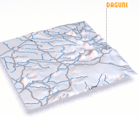 Places with similar names to Daguni, Nigeria ::
Disclaimer :: Information on this page comes without warranty of any kind |
||
|
Where is Daguni? Elevation and coordinates ::
Latitude (lat): 8°31'0"N Longitude (lon): 11°58'0"E
Elevation (approx.): 516m (map arrows pan, magnifying glasses zoom) |
||
|
Visiting Daguni? Hotel/Accommodation ::
Book a hotel in Daguni Travel Guide ::
Buy a travel guide for Nigeria rental cars ::
car rental offers GPS waypoint ::
download a GPX waypoint (PoI) of Daguni for your GPS receiver
|
||