|
search place name
|
||
Dutsel (Gongola, Nigeria)Dutsel is a town in the Gongola region of Nigeria. An overview map of the region around Dutsel is displayed below.
regional and 3d topo map of Dutsel, Nigeria ::

Dutsel airports ::
The nearest airport is SKO - Sokoto Sadiq Abubakar Iii Intl, located 74.9 km north east of Dutsel.
Nearby towns ::
Amore (0.0km north) //
Ungwa Enwu (1.8km west) //
Amore Aduway (3.6km east) //
Magun (4.1km north west) //
Danjema (5.2km north west) //
Banda Sule (7.5km west) //
Sesheda (8.1km south east) //
Gwandu (8.2km south east) //
Bagare (9.1km south east) //
Mebarmi (9.1km north west) //
Langarma (10.4km north west) //
[all distances 'as the bird flies' and approximate] 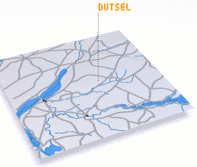 Places with similar names to Dutsel, Nigeria ::
// Detzel (DE)
// Didšiliai (LT)
// Didžiuliai (LT)
// Datta Solla (BD)
// Tetsalia (CR)
// Tadzle (GH)
// Taedusil (KR)
// Dadizele (BE)
// Dudzele (BE)
// Dutsel (BE)
Disclaimer :: Information on this page comes without warranty of any kind |
||
|
Where is Dutsel? Elevation and coordinates ::
Latitude (lat): 12°34'0"N Longitude (lon): 4°37'0"E
Elevation (approx.): 270m (map arrows pan, magnifying glasses zoom) |
||
|
Visiting Dutsel? Hotel/Accommodation ::
Book a hotel in Dutsel Travel Guide ::
Buy a travel guide for Nigeria rental cars ::
car rental offers GPS waypoint ::
download a GPX waypoint (PoI) of Dutsel for your GPS receiver
|
||