|
search place name
|
||
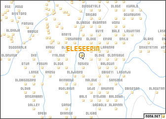
Elese Erin (Gongola, Nigeria)Elese Erin is a town in the Gongola region of Nigeria. An overview map of the region around Elese Erin is displayed below.
regional and 3d topo map of Elese Erin, Nigeria ::
Elese Erin airports ::
The nearest airport is IBA - Ibadan, located 16.3 km north of Elese Erin.
Other airports nearby include LOS - Lagos Murtala Muhammed (103.1 km south west), AKR - Akure (143.7 km east), ILR - Ilorin (145.9 km north), COO - Cotonou Cadjehoun (202.3 km south west), Nearby towns ::
Nosiru (1.9km south) //
Jegede (1.9km south) //
Alabidun (1.8km east) //
Akinkemi (1.8km east) //
Apabiekun (2.6km north east) //
Jigan (3.7km east) //
Olowe (3.7km east) //
Kate (3.7km east) //
Abi Iba (3.7km west) //
Akinlade (3.7km south) //
Oloje (4.1km north west) //
Gbedun (4.1km north east) //
Osun Aro (4.1km north west) //
Adesiyan (4.1km south west) //
Apapa (4.1km south east) //
Amodu (4.1km south east) //
Buraimoh (4.1km north east) //
Oloke (4.1km north east) //
Olojuoro (4.1km south west) //
Ojebode (5.2km north east) //
Olode (5.2km north east) //
Igikola (5.2km south east) //
Lasegbe (5.4km north west) //
Iyalode (5.5km west) //
Laogun (5.6km north) //
Alaje (5.5km east) //
Lapanpa (5.8km east) //
Olode (5.8km west) //
Balogun (5.8km east) //
[all distances 'as the bird flies' and approximate]  Places with similar names to Elese Erin, Nigeria ::
// El Zrahna (MA)
// Elsern (AT)
// El Sereno (US)
// El Zurrón (PA)
// El Zurrón (PA)
// El Serrano (ES)
// El Serrón (ES)
// El Soriano (ES)
// El Cerrón (SV)
// El Cerrón (GT)
Disclaimer :: Information on this page comes without warranty of any kind |
||
|
Where is Elese Erin? Elevation and coordinates ::
Latitude (lat): 7°13'0"N Longitude (lon): 4°0'0"E
Elevation (approx.): 117m (map arrows pan, magnifying glasses zoom) |
||
|
Visiting Elese Erin? Hotel/Accommodation ::
Book a hotel in Elese Erin Travel Guide ::
Buy a travel guide for Nigeria rental cars ::
car rental offers GPS waypoint ::
download a GPX waypoint (PoI) of Elese Erin for your GPS receiver
|
||