|
search place name
|
||
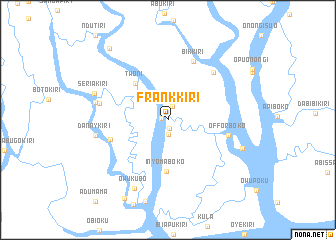
Frankkiri (Gongola, Nigeria)Frankkiri is a town in the Gongola region of Nigeria. An overview map of the region around Frankkiri is displayed below.
regional and 3d topo map of Frankkiri, Nigeria ::
Frankkiri airports ::
The nearest airport is PHC - Port Hartcourt Port Harcourt Intl, located 73.3 km north east of Frankkiri.
Other airports nearby include CBQ - Calabar (201.7 km east), BNI - Benin (234.8 km north west), Nearby towns ::
Josephkiri (0.7km west) //
Orugbanikiri (1.0km south) //
Barapakama (1.6km north) //
Ebinikiri (1.7km south) //
Twoni (5.4km north west) //
Inyomaboko (5.7km south) //
Ejekiri (6.7km west) //
Offorboko (6.9km east) //
Bikkiri (7.2km north east) //
Egbeboko (7.4km north east) //
Charleykiri (7.8km west) //
Dannykiri (8.3km west) //
Nyounkiri (8.3km west) //
Owukubo (8.4km south west) //
Seriakiri (8.7km west) //
Offorsuokiri (8.9km east) //
Ikiriko Ideikiri (10.0km south west) //
Goldsmithkiri (10.3km north west) //
[all distances 'as the bird flies' and approximate]  Places with similar names to Frankkiri, Nigeria ::
// Furnicari (RO)
// Franqueira (ES)
// Verinkèra (BF)
// Frenguéré (CF)
// Furunguero (VE)
// Francoeur (FR)
// Franquier (BE)
// Franeker (NL)
Disclaimer :: Information on this page comes without warranty of any kind |
||
|
Where is Frankkiri? Elevation and coordinates ::
Latitude (lat): 4°26'55"N Longitude (lon): 6°36'23"E
Elevation (approx.): 4m (map arrows pan, magnifying glasses zoom) |
||
|
Visiting Frankkiri? Hotel/Accommodation ::
Book a hotel in Frankkiri Travel Guide ::
Buy a travel guide for Nigeria rental cars ::
car rental offers GPS waypoint ::
download a GPX waypoint (PoI) of Frankkiri for your GPS receiver
|
||