|
search place name
|
||
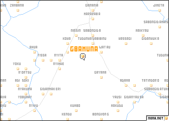
Gbamuna (Gongola, Nigeria)Gbamuna is a town in the Gongola region of Nigeria. An overview map of the region around Gbamuna is displayed below.
regional and 3d topo map of Gbamuna, Nigeria ::
Gbamuna airports ::
The nearest airport is BPC - Bamenda, located 154.4 km south of Gbamuna.
Other airports nearby include MDI - Makurdi (194.2 km west), FOM - Foumban Nkounja (201.8 km south), BFX - Bafoussam (207.9 km south), Nearby towns ::
Audu Maikyauta (4.1km north west) //
Gidan Jatau (4.1km north east) //
Tudun Wada Bibinu (4.1km north east) //
Kowa (5.2km north west) //
Gayama (5.2km south east) //
Nyita (5.5km west) //
Nyabe (5.8km west) //
Nyimwe (5.8km west) //
Sabon Gida (5.9km north) //
Nukuya (5.9km north) //
Nissin (5.9km north) //
Iyorver (7.4km west) //
Gidan Makeri (10.4km south west) //
[all distances 'as the bird flies' and approximate]  Places with similar names to Gbamuna, Nigeria ::
// Kay Bamban (PH)
// Kebaman (ID)
// Kebumen (ID)
// Gbamani (SL)
// Gbombana (SL)
// Gbombana (SL)
// Gbombana (SL)
// Gbombana (SL)
// Cabo Maioane (MZ)
// Kabaman (PG)
Disclaimer :: Information on this page comes without warranty of any kind |
||
|
Where is Gbamuna? Elevation and coordinates ::
Latitude (lat): 7°25'0"N Longitude (lon): 10°21'0"E
Elevation (approx.): 213m (map arrows pan, magnifying glasses zoom) |
||
|
Visiting Gbamuna? Hotel/Accommodation ::
Book a hotel in Gbamuna Travel Guide ::
Buy a travel guide for Nigeria rental cars ::
car rental offers GPS waypoint ::
download a GPX waypoint (PoI) of Gbamuna for your GPS receiver
|
||