|
search place name
|
||
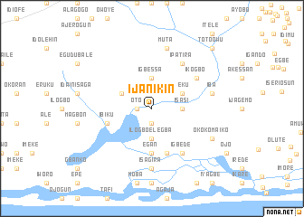
Ijanikin (Gongola, Nigeria)Ijanikin is a town in the Gongola region of Nigeria. An overview map of the region around Ijanikin is displayed below.
regional and 3d topo map of Ijanikin, Nigeria ::
Ijanikin airports ::
The nearest airport is LOS - Lagos Murtala Muhammed, located 22.5 km north east of Ijanikin.
Other airports nearby include COO - Cotonou Cadjehoun (84.3 km west), IBA - Ibadan (133.5 km north east), LFW - Lome Gnassingbe Eyadema Intl (211.1 km west), ILR - Ilorin (261.9 km north east), Nearby towns ::
Oto (1.8km west) //
Era (1.9km south) //
Ilogbo Elegba (3.7km south) //
Igbessa (3.7km north) //
Isasi (3.7km east) //
Agbara (4.1km north west) //
Iteku (4.1km north east) //
Egan (5.6km south) //
Ibiku (5.8km west) //
Etegbin (5.9km south) //
Ikogbo (6.7km north east) //
Agelete (6.7km north east) //
Ipatira (6.7km north east) //
Igbede (6.7km south east) //
Isagira (7.4km south) //
Muta (7.6km north) //
Iba (7.6km east) //
Okokomaiko (8.2km south east) //
Toto Owu (10.4km north east) //
[all distances 'as the bird flies' and approximate] 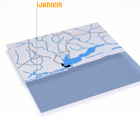
Disclaimer :: Information on this page comes without warranty of any kind |
||
|
Where is Ijanikin? Elevation and coordinates ::
Latitude (lat): 6°30'0"N Longitude (lon): 3°8'0"E
Elevation (approx.): 4m (map arrows pan, magnifying glasses zoom) |
||
|
Visiting Ijanikin? Hotel/Accommodation ::
Book a hotel in Ijanikin Travel Guide ::
Buy a travel guide for Nigeria rental cars ::
car rental offers GPS waypoint ::
download a GPX waypoint (PoI) of Ijanikin for your GPS receiver
|
||