|
search place name
|
||
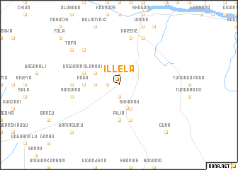
Illela (Gongola, Nigeria)Illela is a town in the Gongola region of Nigeria. An overview map of the region around Illela is displayed below.
regional and 3d topo map of Illela, Nigeria ::
Illela airports ::
The nearest airport is SKO - Sokoto Sadiq Abubakar Iii Intl, located 49.8 km north east of Illela.
Other airports nearby include QUS - Gusau (192.3 km east), Nearby towns ::
Barkini (1.9km south) //
Tudun Wada (1.8km west) //
Babuji (1.9km north) //
Aggur (1.9km north) //
Gidan Mangoro (1.8km west) //
Kajiji (3.6km west) //
Jabo (3.9km south) //
Sakanaw (4.1km south east) //
Busawa (4.1km north west) //
Kaisoje (4.1km north west) //
Roga (5.4km west) //
Pilia (5.6km south) //
Kagara (5.8km south) //
Ungwan Malamawa (5.7km west) //
Hausare (7.2km west) //
Mareke (7.6km north) //
Mandera (7.5km west) //
Runji (7.8km north west) //
Rugan Burla (7.8km north west) //
Kaura (8.2km north east) //
Karoga (9.1km north west) //
Sainyinan Yabo (9.1km north west) //
Tofa (9.1km north west) //
Guma (10.4km south east) //
Daringuru (10.4km south west) //
[all distances 'as the bird flies' and approximate]  Places with similar names to Illela, Nigeria ::
Disclaimer :: Information on this page comes without warranty of any kind |
||
|
Where is Illela? Elevation and coordinates ::
Latitude (lat): 12°32'0"N Longitude (lon): 4°58'0"E
Elevation (approx.): 278m (map arrows pan, magnifying glasses zoom) |
||
|
Visiting Illela? Hotel/Accommodation ::
Book a hotel in Illela Travel Guide ::
Buy a travel guide for Nigeria rental cars ::
car rental offers GPS waypoint ::
download a GPX waypoint (PoI) of Illela for your GPS receiver
|
||