|
search place name
|
||
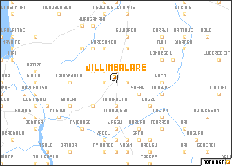
Jilli Mbalare (Gongola, Nigeria)Jilli Mbalare is a town in the Gongola region of Nigeria. An overview map of the region around Jilli Mbalare is displayed below.
regional and 3d topo map of Jilli Mbalare, Nigeria ::
Jilli Mbalare airports ::
The nearest airport is YOL - Yola, located 21.7 km north of Jilli Mbalare.
Other airports nearby include GOU - Garoua (112.5 km east), NGE - N'gaoundere Ngaoundere (229.2 km south east), MVR - Maroua Salak (256.4 km north east), Nearby towns ::
Jilli (1.9km north) //
Wafango (1.8km west) //
Mayo Daleje (1.8km east) //
Wuro Adayel (2.6km north west) //
Tawa Fulani (3.7km south) //
Tawa Dundere (3.7km south) //
Kwai Petel (4.1km north west) //
Sheba (4.1km south east) //
Babuba (5.2km south west) //
Tawa Jabbi (5.6km south) //
Wuro Sambo (5.9km north) //
Dumayo (5.9km north) //
Jaccingo (6.7km north west) //
Lugzo (6.6km south east) //
Lainde Jalo (7.3km west) //
Gurumpawo (7.3km east) //
Wayo (7.3km east) //
Jaggu (7.4km south) //
Gujibabu (7.6km north) //
Tongare (7.6km east) //
Labbare (7.6km east) //
Kohi Petel (7.8km north west) //
Bauchi (8.2km south west) //
Lomorgel (8.2km north east) //
Karlahi (8.3km south east) //
Tuki (9.2km north east) //
Walipa (9.2km south east) //
Nyibango (9.2km south west) //
Baraji (10.4km north east) //
[all distances 'as the bird flies' and approximate] 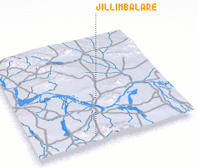 Places with similar names to Jilli Mbalare, Nigeria :: Disclaimer :: Information on this page comes without warranty of any kind |
||
|
Where is Jilli Mbalare? Elevation and coordinates ::
Latitude (lat): 9°4'0"N Longitude (lon): 12°23'0"E
Elevation (approx.): 288m (map arrows pan, magnifying glasses zoom) |
||
|
Visiting Jilli Mbalare? Hotel/Accommodation ::
Book a hotel in Jilli Mbalare Travel Guide ::
Buy a travel guide for Nigeria rental cars ::
car rental offers GPS waypoint ::
download a GPX waypoint (PoI) of Jilli Mbalare for your GPS receiver
|
||