|
search place name
|
||
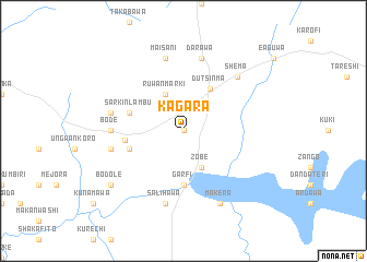
Kagara (Gongola, Nigeria)Kagara is a town in the Gongola region of Nigeria. An overview map of the region around Kagara is displayed below.
regional and 3d topo map of Kagara, Nigeria ::
Kagara airports ::
The nearest airport is QUS - Gusau, located 88.1 km west of Kagara.
Other airports nearby include KAN - Kano Mallam Aminu Intl (122.1 km east), MFG - Maradi (125.7 km north), ZAR - Zaria (144.3 km south), KAD - Kaduna (191.0 km south), Nearby towns ::
Mahuta (0.0km north) //
Ruwan Marki (4.1km north west) //
Zobe (4.1km south east) //
Katsali (4.1km south east) //
Dutsin-Ma (5.0km north east) //
Garfi (5.6km south) //
Sarkin Lambu (5.7km west) //
Sasaya (5.7km west) //
Salhala (5.7km west) //
Safana (6.0km west) //
Bode (7.2km west) //
Darawa (7.6km north) //
Maisani (7.6km north) //
Dan Nagayo (7.5km west) //
Koria (7.5km west) //
Hakazama (7.6km south) //
Salihawa (7.6km south) //
Shema (7.8km north east) //
Makera (8.3km south east) //
Bodole (9.1km south west) //
[all distances 'as the bird flies' and approximate] 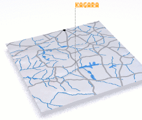 Places with similar names to Kagara, Nigeria ::
Disclaimer :: Information on this page comes without warranty of any kind |
||
|
Where is Kagara? Elevation and coordinates ::
Latitude (lat): 12°25'0"N Longitude (lon): 7°28'0"E
Elevation (approx.): 500m (map arrows pan, magnifying glasses zoom) |
||
|
Visiting Kagara? Hotel/Accommodation ::
Book a hotel in Kagara Travel Guide ::
Buy a travel guide for Nigeria rental cars ::
car rental offers GPS waypoint ::
download a GPX waypoint (PoI) of Kagara for your GPS receiver
|
||