|
search place name
|
||
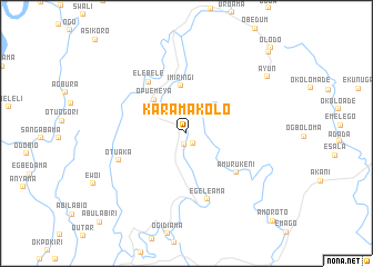
Karama Kolo (Gongola, Nigeria)Karama Kolo is a town in the Gongola region of Nigeria. An overview map of the region around Karama Kolo is displayed below.
regional and 3d topo map of Karama Kolo, Nigeria ::
Karama Kolo airports ::
The nearest airport is PHC - Port Hartcourt Port Harcourt Intl, located 67.4 km east of Karama Kolo.
Other airports nearby include BNI - Benin (187.7 km north west), CBQ - Calabar (219.3 km east), ENU - Enugu (226.1 km north east), Nearby towns ::
Kala Kolo (1.1km south) //
Opu Kolo (1.2km south east) //
Kala Emeya (3.6km north west) //
Opu Emeya (4.6km north west) //
Imiringi (4.8km north) //
Amurukeni (6.3km south east) //
Elebele (6.4km north west) //
Egeleama (6.9km south) //
Otuaka (7.4km west) //
Ayun (9.9km north east) //
Amerikpoko (11.6km north east) //
Olodo (12.0km north east) //
Amoroto (12.3km south east) //
[all distances 'as the bird flies' and approximate] 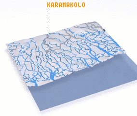 Places with similar names to Karama Kolo, Nigeria ::
// Kurmėgala (LT)
// Carramiguel (ES)
// Kromkuil (ZA)
// Karmakla (RU)
// Kromkol (KG)
// Keur Makala (SN)
// Karmakol (SD)
// Karam Qolī (IR)
// Karīm Kolā (IR)
// Karam Kili (PK)
Disclaimer :: Information on this page comes without warranty of any kind |
||
|
Where is Karama Kolo? Elevation and coordinates ::
Latitude (lat): 4°48'34"N Longitude (lon): 6°22'38"E
Elevation (approx.): 8m (map arrows pan, magnifying glasses zoom) |
||
|
Visiting Karama Kolo? Hotel/Accommodation ::
Book a hotel in Karama Kolo Travel Guide ::
Buy a travel guide for Nigeria rental cars ::
car rental offers GPS waypoint ::
download a GPX waypoint (PoI) of Karama Kolo for your GPS receiver
|
||