|
search place name
|
||
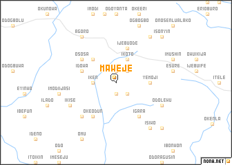
Maweje (Gongola, Nigeria)Maweje is a town in the Gongola region of Nigeria. An overview map of the region around Maweje is displayed below.
regional and 3d topo map of Maweje, Nigeria ::
Maweje airports ::
The nearest airport is IBA - Ibadan, located 66.2 km north of Maweje.
Other airports nearby include LOS - Lagos Murtala Muhammed (69.1 km west), AKR - Akure (161.9 km east), COO - Cotonou Cadjehoun (175.4 km west), BNI - Benin (192.6 km east), Nearby towns ::
Ogbo (1.9km north) //
Ibido (1.9km south) //
Ijagun (2.6km north east) //
Odo Siwaren (2.6km south east) //
Idagbo (2.6km south east) //
Ala (3.7km west) //
Iken (3.7km west) //
Ikoto (4.1km north east) //
Egbe (5.2km north west) //
Yemoji (5.5km east) //
Imagbon (5.5km east) //
Idowa (5.8km west) //
Ijebu Ode (5.9km north) //
Ososa (6.6km north west) //
Igara (6.7km south east) //
Oke Odun (6.7km south west) //
Igbile (7.8km south west) //
Odo Lagaye (8.2km south east) //
Odo Lewu (8.2km south east) //
Ikise (8.2km south west) //
Agoro (9.2km north west) //
Erunwon (9.2km north east) //
Isiwo (9.2km south east) //
Isonyin (10.4km north east) //
Agboju (10.4km south east) //
[all distances 'as the bird flies' and approximate] 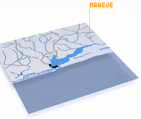 Places with similar names to Maweje, Nigeria ::
Disclaimer :: Information on this page comes without warranty of any kind |
||
|
Where is Maweje? Elevation and coordinates ::
Latitude (lat): 6°46'0"N Longitude (lon): 3°55'0"E
Elevation (approx.): 36m (map arrows pan, magnifying glasses zoom) |
||
|
Visiting Maweje? Hotel/Accommodation ::
Book a hotel in Maweje Travel Guide ::
Buy a travel guide for Nigeria rental cars ::
car rental offers GPS waypoint ::
download a GPX waypoint (PoI) of Maweje for your GPS receiver
|
||