|
search place name
|
||
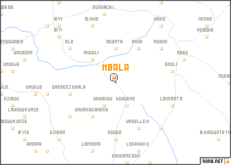
Mbala (Gongola, Nigeria)Mbala is a town in the Gongola region of Nigeria. An overview map of the region around Mbala is displayed below.
regional and 3d topo map of Mbala, Nigeria ::
Mbala airports ::
The nearest airport is ENU - Enugu, located 52.6 km north of Mbala.
Other airports nearby include PHC - Port Hartcourt Port Harcourt Intl (122.4 km south west), CBQ - Calabar (158.4 km south east), BNI - Benin (199.9 km west), MDI - Makurdi (229.4 km north east), Nearby towns ::
Umuakwu (4.1km south west) //
Ugwueme (4.1km south east) //
Amawda (4.1km south east) //
Nkwuli (5.2km north west) //
Ogunta (5.6km north) //
Umu Akwu Ameke (6.7km south west) //
Nkwe (6.7km north east) //
Owere Ezukala (7.6km west) //
Umuellem (8.3km south east) //
Obulo Eziama (9.2km south west) //
Olo (9.2km north west) //
Mgbidi (9.2km north east) //
Lekwesi (10.5km south east) //
[all distances 'as the bird flies' and approximate] 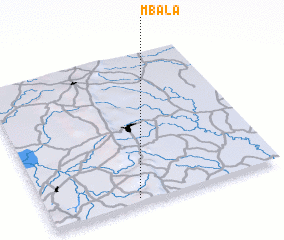 Places with similar names to Mbala, Nigeria ::
Disclaimer :: Information on this page comes without warranty of any kind |
||
|
Where is Mbala? Elevation and coordinates ::
Latitude (lat): 6°2'0"N Longitude (lon): 7°23'0"E
Elevation (approx.): 340m (map arrows pan, magnifying glasses zoom) |
||
|
Visiting Mbala? Hotel/Accommodation ::
Book a hotel in Mbala Travel Guide ::
Buy a travel guide for Nigeria rental cars ::
car rental offers GPS waypoint ::
download a GPX waypoint (PoI) of Mbala for your GPS receiver
|
||