|
search place name
|
||
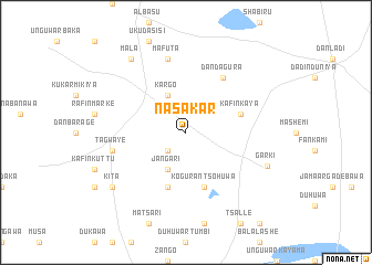
Nasakar (Gongola, Nigeria)Nasakar is a town in the Gongola region of Nigeria. An overview map of the region around Nasakar is displayed below.
regional and 3d topo map of Nasakar, Nigeria ::
Nasakar airports ::
The nearest airport is KAN - Kano Mallam Aminu Intl, located 79.4 km south west of Nasakar.
Other airports nearby include ZND - Zinder (145.9 km north), ZAR - Zaria (214.9 km south west), MFG - Maradi (244.4 km north west), KAD - Kaduna (277.0 km south west), Nearby towns ::
Bakar Sabara (2.6km south west) //
Kargo (4.1km north west) //
Jangari (4.1km south west) //
Koguran Tsohuwa (5.8km south) //
Kafin Kaya (5.7km east) //
Gwadayawa (5.8km south) //
Dan Dagura (6.6km north east) //
Mafuta (7.6km north) //
Tagwaye (7.5km west) //
Garki (8.7km south east) //
Mala (9.2km north west) //
Kita (9.1km south west) //
[all distances 'as the bird flies' and approximate] 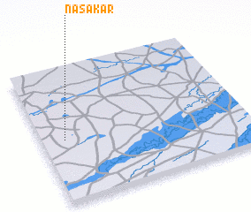 Places with similar names to Nasakar, Nigeria ::
// Nuzgǝr (AZ)
// Nüzgǝr (AZ)
// Neu Sacro (DE)
// New Square (US)
// Néssagarou (BF)
// Nzakara (CF)
// Nusakar (ID)
// Nosuguro (KE)
// Niskora (PK)
// Niesgrau (DE)
Disclaimer :: Information on this page comes without warranty of any kind |
||
|
Where is Nasakar? Elevation and coordinates ::
Latitude (lat): 12°28'0"N Longitude (lon): 9°7'0"E
Elevation (approx.): 379m (map arrows pan, magnifying glasses zoom) |
||
|
Visiting Nasakar? Hotel/Accommodation ::
Book a hotel in Nasakar Travel Guide ::
Buy a travel guide for Nigeria rental cars ::
car rental offers GPS waypoint ::
download a GPX waypoint (PoI) of Nasakar for your GPS receiver
|
||