|
search place name
|
||
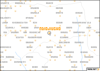
Ndioji Ugwo (Gongola, Nigeria)Ndioji Ugwo is a town in the Gongola region of Nigeria. An overview map of the region around Ndioji Ugwo is displayed below.
regional and 3d topo map of Ndioji Ugwo, Nigeria ::
Ndioji Ugwo airports ::
The nearest airport is ENU - Enugu, located 96.1 km north of Ndioji Ugwo.
Other airports nearby include CBQ - Calabar (100.8 km south east), PHC - Port Hartcourt Port Harcourt Intl (106.5 km south west), SSG - Malabo (234.3 km south east), TKC - Tiko (249.9 km south east), Nearby towns ::
Anna Abam (1.9km south) //
Ndi Ebe (1.8km east) //
Umuhu Abam (4.1km north west) //
Onuasu (4.1km south east) //
Oduenyi (4.1km south east) //
Ogo Ubi (5.2km north east) //
Amaeke Abam (5.2km south west) //
Ndi Ebeleagu (5.2km south east) //
Ama Uru (5.5km east) //
Ndinya (5.6km south) //
Neke Mecha (5.5km west) //
Ozu Abam (5.8km east) //
Ndiebe Amagbo (5.8km west) //
Amizu (6.7km south east) //
Ndi Ememe Abam (6.7km south east) //
Achi (6.7km north west) //
Amelu Abam (6.7km south east) //
Idima (7.4km south) //
Oboro (7.6km east) //
Amanta (8.3km north east) //
Ndi Ekete (8.3km south east) //
Obuohia (8.3km south west) //
Ohumola (9.3km north west) //
Ndi Ite (9.3km south east) //
Bende (9.2km south west) //
Afia Usu (9.2km north west) //
Ndi Okorie (10.5km south east) //
[all distances 'as the bird flies' and approximate] 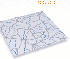 Places with similar names to Ndioji Ugwo, Nigeria :: Disclaimer :: Information on this page comes without warranty of any kind |
||
|
Where is Ndioji Ugwo? Elevation and coordinates ::
Latitude (lat): 5°37'0"N Longitude (lon): 7°42'0"E
Elevation (approx.): 44m (map arrows pan, magnifying glasses zoom) |
||
|
Visiting Ndioji Ugwo? Hotel/Accommodation ::
Book a hotel in Ndioji Ugwo Travel Guide ::
Buy a travel guide for Nigeria rental cars ::
car rental offers GPS waypoint ::
download a GPX waypoint (PoI) of Ndioji Ugwo for your GPS receiver
|
||