|
search place name
|
||
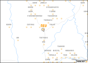
Nev (Gongola, Nigeria)Nev is a town in the Gongola region of Nigeria. An overview map of the region around Nev is displayed below.
regional and 3d topo map of Nev, Nigeria ::
Nev airports ::
The nearest airport is MDI - Makurdi, located 15.3 km north of Nev.
Other airports nearby include ENU - Enugu (166.6 km south west), ABV - Abuja Nnamdi Azikiwe Intl (216.9 km north west), BPC - Bamenda (238.5 km south east), Nearby towns ::
Amiza (2.6km north west) //
Benge (2.6km north west) //
Daju (2.6km north west) //
Tse Tsuwe (3.7km south) //
Tse Abor (3.7km south) //
Tse Jir (4.1km north east) //
Tse Aduku (4.1km north east) //
Gnu (5.6km south) //
Zenyaku (5.8km west) //
Iyorember Aninov (6.7km north west) //
Tse Usange (6.7km north east) //
Okabi (7.6km west) //
Ayisa (7.8km north east) //
Tse Kyado (7.8km north east) //
Sum Apir (8.3km north west) //
Stasungu (8.3km north west) //
Kwembe (8.3km north east) //
Tyokaa (8.3km north east) //
Gbashima (9.2km north west) //
Apir (9.2km north west) //
Ugoh (9.2km north west) //
Gwegwe (9.2km north east) //
Tse Kyula (9.2km north east) //
Tswakaa (10.4km south east) //
[all distances 'as the bird flies' and approximate]  Places with similar names to Nev, Nigeria ::
Disclaimer :: Information on this page comes without warranty of any kind |
||
|
Where is Nev? Elevation and coordinates ::
Latitude (lat): 7°34'0"N Longitude (lon): 8°36'0"E
Elevation (approx.): 175m (map arrows pan, magnifying glasses zoom) |
||
|
Visiting Nev? Hotel/Accommodation ::
Book a hotel in Nev Travel Guide ::
Buy a travel guide for Nigeria rental cars ::
car rental offers GPS waypoint ::
download a GPX waypoint (PoI) of Nev for your GPS receiver
|
||