|
search place name
|
||
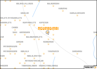
Nguradina I (Gongola, Nigeria)Nguradina I is a town in the Gongola region of Nigeria. An overview map of the region around Nguradina I is displayed below.
regional and 3d topo map of Nguradina I, Nigeria ::
Nguradina I airports ::
The nearest airport is MIU - Maiduguri, located 111.9 km north of Nguradina I.
Other airports nearby include MVR - Maroua Salak (147.9 km east), GOU - Garoua (173.2 km south), YOL - Yola (185.7 km south), Nearby towns ::
Kauyaga (1.8km east) //
Manawaji (1.9km south) //
Kaumutuyahi (1.9km north) //
Nguradina II (1.9km south) //
Kaurwatikari (2.6km south east) //
Kakilmari (2.6km north east) //
Ngaburawa (3.7km south) //
Bovtari (4.1km north west) //
Kufazigai (4.1km north west) //
Koshama Hamlets (4.1km south west) //
Bulabum Hamlets (5.8km west) //
Kuburmbula (6.6km north west) //
Yimurmunza (7.6km south) //
Pemi Bulali (7.6km south) //
Mumfi Hamlets (8.2km north west) //
[all distances 'as the bird flies' and approximate]  Places with similar names to Nguradina I, Nigeria ::
// Naugarten (DE)
// New Corydon (US)
// Neugarten (DE)
// New Garden (US)
// New Gretna (US)
// New Garden (US)
// New Garden (US)
// Nowgardan (IR)
// Nukradin (PK)
// Nguradina II (NG)
Disclaimer :: Information on this page comes without warranty of any kind |
||
|
Where is Nguradina I? Elevation and coordinates ::
Latitude (lat): 10°51'0"N Longitude (lon): 12°58'0"E
Elevation (approx.): 472m (map arrows pan, magnifying glasses zoom) |
||
|
Visiting Nguradina I? Hotel/Accommodation ::
Book a hotel in Nguradina I Travel Guide ::
Buy a travel guide for Nigeria rental cars ::
car rental offers GPS waypoint ::
download a GPX waypoint (PoI) of Nguradina I for your GPS receiver
|
||