|
search place name
|
||
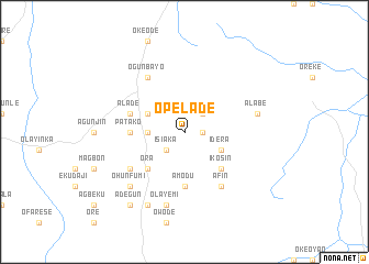
Opelade (Gongola, Nigeria)Opelade is a town in the Gongola region of Nigeria. An overview map of the region around Opelade is displayed below.
regional and 3d topo map of Opelade, Nigeria ::
Opelade airports ::
The nearest airport is ILR - Ilorin, located 63.1 km west of Opelade.
Other airports nearby include AKR - Akure (137.4 km south), IBA - Ibadan (171.2 km south west), MXJ - Minna New (201.8 km north east), LOS - Lagos Murtala Muhammed (284.2 km south west), Nearby towns ::
Budoare (1.8km east) //
Olodan (2.6km north east) //
Aiyereke (2.6km south west) //
Isiaka (2.6km south west) //
Ita Olowo (3.7km west) //
Idera (4.1km south east) //
Ajia (4.1km north west) //
Ikosin (5.2km south east) //
Ora (5.2km south west) //
Balogun Budoloke (5.2km south west) //
Amodu (5.6km south) //
Patako (5.5km west) //
Alade (5.8km west) //
Afin (6.7km south east) //
Alama (6.6km south west) //
Ogunbayo (6.7km north west) //
Alabe (7.6km east) //
Gboloko (7.6km south) //
Olayemi (7.6km south) //
Ohunfumi (7.8km south west) //
Mainasara (8.3km south west) //
Adegun (9.2km south west) //
[all distances 'as the bird flies' and approximate] 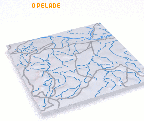
Disclaimer :: Information on this page comes without warranty of any kind |
||
|
Where is Opelade? Elevation and coordinates ::
Latitude (lat): 8°28'0"N Longitude (lon): 5°4'0"E
Elevation (approx.): 280m (map arrows pan, magnifying glasses zoom) |
||
|
Visiting Opelade? Hotel/Accommodation ::
Book a hotel in Opelade Travel Guide ::
Buy a travel guide for Nigeria rental cars ::
car rental offers GPS waypoint ::
download a GPX waypoint (PoI) of Opelade for your GPS receiver
|
||