|
search place name
|
||
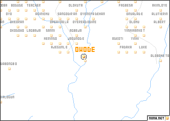
Owode (Gongola, Nigeria)Owode is a town in the Gongola region of Nigeria. An overview map of the region around Owode is displayed below.
regional and 3d topo map of Owode, Nigeria ::
Owode airports ::
The nearest airport is IBA - Ibadan, located 51.4 km north west of Owode.
Other airports nearby include AKR - Akure (102.1 km east), LOS - Lagos Murtala Muhammed (132.5 km south west), ILR - Ilorin (145.0 km north), BNI - Benin (162.0 km south east), Nearby towns ::
Shasha (0.0km north) //
Mokore (4.1km north west) //
Jagunode (4.1km north west) //
Araromi Owu (4.1km north west) //
Awaiye (5.2km north west) //
Agbeja (5.9km north) //
Ajegunle (5.8km west) //
Elegbeje (6.6km north west) //
Oyere Adedire (7.4km north) //
Araromi Okeodo (7.6km east) //
Alafia (7.8km north west) //
Budale (7.8km north west) //
Olamuyiwa (7.8km north west) //
Ajebandele (7.8km north west) //
Merinso (8.2km north west) //
Adeoti (8.2km north east) //
Sanni (9.2km north west) //
Ope Ayoola (9.2km north west) //
Olodu (9.2km north west) //
Omirin (10.4km north west) //
[all distances 'as the bird flies' and approximate]  Places with similar names to Owode, Nigeria ::
Disclaimer :: Information on this page comes without warranty of any kind |
||
|
Where is Owode? Elevation and coordinates ::
Latitude (lat): 7°8'0"N Longitude (lon): 4°23'0"E
Elevation (approx.): 125m (map arrows pan, magnifying glasses zoom) |
||
|
Visiting Owode? Hotel/Accommodation ::
Book a hotel in Owode Travel Guide ::
Buy a travel guide for Nigeria rental cars ::
car rental offers GPS waypoint ::
download a GPX waypoint (PoI) of Owode for your GPS receiver
|
||