|
search place name
|
||
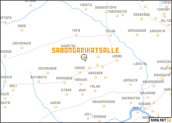
Sabon Gari Katsalle (Kano, Nigeria)Sabon Gari Katsalle is a town in the Kano region of Nigeria. An overview map of the region around Sabon Gari Katsalle is displayed below.
regional and 3d topo map of Sabon Gari Katsalle, Nigeria ::
Sabon Gari Katsalle airports ::
The nearest airport is KAN - Kano Mallam Aminu Intl, located 25.7 km east of Sabon Gari Katsalle.
Other airports nearby include ZAR - Zaria (117.3 km south west), QUS - Gusau (174.8 km west), KAD - Kaduna (179.6 km south west), MFG - Maradi (208.5 km north west), Nearby towns ::
Doka (1.4km south east) //
Kadane (1.4km north west) //
Farin Ruwa (2.4km east) //
Zango (2.6km south west) //
Kwami (2.8km north east) //
Ungwan Dawa (3.6km east) //
Wangara (4.0km south east) //
Duwatsu (4.5km north west) //
Yan Kuni (5.0km south) //
Ungwan Rimi (5.4km south east) //
Tofa (6.3km north) //
Rimin Gado (6.5km south west) //
Yalwa (6.7km south) //
Lambu (6.7km east) //
Juji (7.2km south) //
Yelwa (7.7km north east) //
Dtawa (8.2km south west) //
Kazar Dawa (8.6km west) //
[all distances 'as the bird flies' and approximate]  Places with similar names to Sabon Gari Katsalle, Nigeria :: Disclaimer :: Information on this page comes without warranty of any kind |
||
|
Where is Sabon Gari Katsalle? Elevation and coordinates ::
Latitude (lat): 12°0'19"N Longitude (lon): 8°17'34"E
Elevation (approx.): 509m (map arrows pan, magnifying glasses zoom) |
||
|
Visiting Sabon Gari Katsalle? Hotel/Accommodation ::
Book a hotel in Sabon Gari Katsalle Travel Guide ::
Buy a travel guide for Nigeria rental cars ::
car rental offers GPS waypoint ::
download a GPX waypoint (PoI) of Sabon Gari Katsalle for your GPS receiver
|
||