|
search place name
|
||
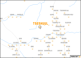
Tseshuul (Gongola, Nigeria)Tseshuul is a town in the Gongola region of Nigeria. An overview map of the region around Tseshuul is displayed below.
regional and 3d topo map of Tseshuul, Nigeria ::
Tseshuul airports ::
The nearest airport is MDI - Makurdi, located 61.8 km north east of Tseshuul.
Other airports nearby include ENU - Enugu (121.9 km south west), ABV - Abuja Nnamdi Azikiwe Intl (200.3 km north west), BPC - Bamenda (267.5 km south east), Nearby towns ::
Achu (2.6km north east) //
Ikpakpev (2.6km north east) //
Mena (4.1km north east) //
Antsum (4.1km north east) //
Akaa (4.1km south east) //
Tsekpe (5.2km south east) //
Anacha (5.2km south east) //
Zauka (5.2km south east) //
Ger (5.6km south) //
Gbawuan (5.6km south) //
Akwaga (5.6km south) //
Tseako (5.6km south) //
Hungo (5.8km east) //
Tseangbir (5.9km south) //
Ukpan (5.9km south) //
Jimin (5.8km east) //
Tar (5.8km east) //
Tseapenda (5.9km south) //
Gbabi (6.6km north east) //
Tseubur (6.6km south east) //
Namshu (7.6km east) //
Tse Akuta (7.6km east) //
Tseundu (7.6km east) //
Dedaro (7.8km north east) //
Ukpe (7.8km north east) //
Ovungu (7.8km north east) //
Asor (7.8km north east) //
Girim (7.8km north east) //
Uzuaban (7.8km south east) //
[all distances 'as the bird flies' and approximate]  Places with similar names to Tseshuul, Nigeria :: Disclaimer :: Information on this page comes without warranty of any kind |
||
|
Where is Tseshuul? Elevation and coordinates ::
Latitude (lat): 7°25'0"N Longitude (lon): 8°8'0"E
Elevation (approx.): 174m (map arrows pan, magnifying glasses zoom) |
||
|
Visiting Tseshuul? Hotel/Accommodation ::
Book a hotel in Tseshuul Travel Guide ::
Buy a travel guide for Nigeria rental cars ::
car rental offers GPS waypoint ::
download a GPX waypoint (PoI) of Tseshuul for your GPS receiver
|
||