|
search place name
|
||
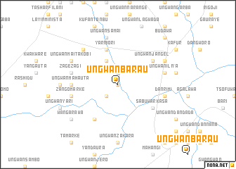
Ungwan Barau (Gongola, Nigeria)Ungwan Barau is a town in the Gongola region of Nigeria. An overview map of the region around Ungwan Barau is displayed below.
regional and 3d topo map of Ungwan Barau, Nigeria ::
Ungwan Barau airports ::
The nearest airport is ZAR - Zaria, located 52.5 km south of Ungwan Barau.
Other airports nearby include KAD - Kaduna (105.1 km south), KAN - Kano Mallam Aminu Intl (110.6 km north east), QUS - Gusau (118.6 km north west), MFG - Maradi (217.1 km north), Nearby towns ::
Dantige (0.0km north) //
Layin Damo (1.9km north) //
Gobirawa (2.6km south west) //
Ungwan Jalatu (4.1km north west) //
Yari Bori (5.8km north) //
Sabuwar Kasa (6.6km south east) //
Ungwan Jangel (6.6km north east) //
Maizaure (6.6km south west) //
Ungwan Barde (7.3km west) //
Ungwan Mahauta (7.3km west) //
Ungwan Iliya (7.5km east) //
Dan Rimi (7.5km east) //
Zango Marke (7.5km west) //
Ungwan Wanzamai (7.5km west) //
Zagezagi (7.5km west) //
Ungwan Samai (7.6km north) //
Ungwan Barkono (7.8km north west) //
Masari (8.2km north east) //
Ungwan Maitakobi (8.2km north west) //
Wangarawa (9.1km south west) //
Budawa (10.4km north east) //
[all distances 'as the bird flies' and approximate] 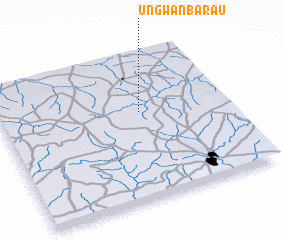 Places with similar names to Ungwan Barau, Nigeria ::
// Ungwan Barau (NG)
// Ungwan Barau (NG)
Disclaimer :: Information on this page comes without warranty of any kind |
||
|
Where is Ungwan Barau? Elevation and coordinates ::
Latitude (lat): 11°36'0"N Longitude (lon): 7°37'0"E
Elevation (approx.): 592m (map arrows pan, magnifying glasses zoom) |
||
|
Visiting Ungwan Barau? Hotel/Accommodation ::
Book a hotel in Ungwan Barau Travel Guide ::
Buy a travel guide for Nigeria rental cars ::
car rental offers GPS waypoint ::
download a GPX waypoint (PoI) of Ungwan Barau for your GPS receiver
|
||