|
search place name
|
||
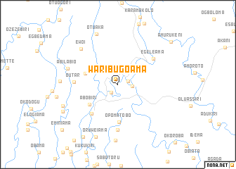
Waribugoama (Gongola, Nigeria)Waribugoama is a town in the Gongola region of Nigeria. An overview map of the region around Waribugoama is displayed below.
regional and 3d topo map of Waribugoama, Nigeria ::
Waribugoama airports ::
The nearest airport is PHC - Port Hartcourt Port Harcourt Intl, located 74.8 km north east of Waribugoama.
Other airports nearby include BNI - Benin (195.6 km north west), ENU - Enugu (236.8 km north east), Nearby towns ::
Okpiniama (1.7km south west) //
Ogidiama (1.7km east) //
Akalabagi (2.3km east) //
Abobiri (5.5km south west) //
Abulabiri (5.5km west) //
Opomatobo (6.0km south) //
Oloibiri (6.2km south west) //
Egeleama (6.9km north east) //
Outar (6.9km west) //
Awiakalakala (7.2km south) //
Ewoi (8.1km north west) //
Abilabio (8.4km west) //
Otuaka (8.6km north west) //
Akipelai (8.9km south) //
Oruweiama (9.0km south west) //
Iyalakiri (9.4km west) //
Ibobio (9.8km south west) //
Ekperikiri (10.0km south west) //
Amurukeni (10.8km north east) //
Eminiama (11.4km south west) //
[all distances 'as the bird flies' and approximate] 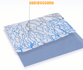 Places with similar names to Waribugoama, Nigeria ::
// Wuro Bakmbo (NG)
Disclaimer :: Information on this page comes without warranty of any kind |
||
|
Where is Waribugoama? Elevation and coordinates ::
Latitude (lat): 4°42'49"N Longitude (lon): 6°20'45"E
Elevation (approx.): 15m (map arrows pan, magnifying glasses zoom) |
||
|
Visiting Waribugoama? Hotel/Accommodation ::
Book a hotel in Waribugoama Travel Guide ::
Buy a travel guide for Nigeria rental cars ::
car rental offers GPS waypoint ::
download a GPX waypoint (PoI) of Waribugoama for your GPS receiver
|
||