|
search place name
|
||
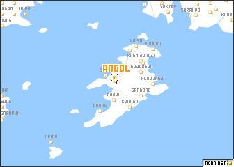
An-gol (P'yŏngan, Korea, North)An-gol is a town in the P'yŏngan region of Korea, North. An overview map of the region around An-gol is displayed below.
regional and 3d topo map of An-gol, Korea, North ::
An-gol airports ::
The nearest airport is FNJ - Pyongyang Intl, located 78.3 km south east of An-gol.
Other airports nearby include GMP - Seoul Gimpo (277.6 km south east), Nearby towns ::
Unjong-ni (0.5km north west) //
Saya (1.9km north west) //
Majŏn (2.7km south) //
Korasa (4.1km south east) //
Sojungji (3.5km north east) //
Sandong (3.6km south east) //
Ŏhang (4.9km south west) //
Kaemijungji (4.7km north east) //
Yŏng-gol (4.6km north east) //
Munsa-ri (5.5km north) //
K'ŭnjungji (4.4km east) //
Kilsa (6.4km north) //
Kinmogi (7.1km north east) //
[all distances 'as the bird flies' and approximate] 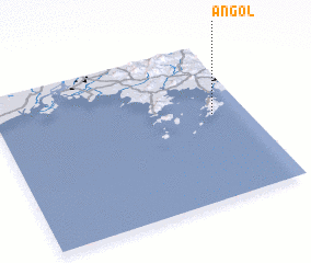 Places with similar names to An-gol, Korea, North ::
Disclaimer :: Information on this page comes without warranty of any kind |
||
|
Where is An-gol? Elevation and coordinates ::
Latitude (lat): 39°33'2"N Longitude (lon): 124°51'54"E
Elevation (approx.): 28m (map arrows pan, magnifying glasses zoom) |
||
|
Visiting An-gol? Hotel/Accommodation ::
Book a hotel in An-gol Travel Guide ::
rental cars ::
car rental offers GPS waypoint ::
download a GPX waypoint (PoI) of An-gol for your GPS receiver
|
||