|
search place name
|
||
Changal-li (Yanggang, Korea, North)Changal-li is a town in the Yanggang region of Korea, North. An overview map of the region around Changal-li is displayed below.
regional and 3d topo map of Changal-li, Korea, North ::
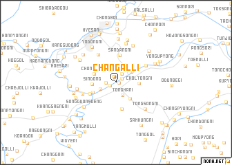
Nearby towns ::
Tokpong (0.4km east) //
Ch'oeobong (0.9km south west) //
An'gye-ri (0.9km north east) //
Changdong-ni (1.2km west) //
Chasal-li (1.6km north east) //
Tongha-ri (2.2km south) //
Changgang-ni (2.2km south west) //
Ongdong-ni (2.5km north east) //
Tongjung-ni (3.2km south east) //
Chŏltŏng-ni (2.8km east) //
Ch'ŏnsŏng-ni (3.0km north west) //
Sin-dong (2.9km west) //
Sinjang-ni (3.2km south west) //
Tongsal-li (4.4km south) //
Unch'ong-ni (3.8km north east) //
Sandang-ni (4.4km north) //
Sinp'ung-ni (3.6km south west) //
Wiju-gol (5.0km north west) //
Majŏl-li (4.6km north east) //
Hagwangsaeng (4.5km south west) //
Tongsang-ni (5.6km south east) //
Changp'ung-ni (4.9km west) //
Sanggwansaeng (5.5km south west) //
Sinhŭng-ni (6.5km north) //
Yŏngch'ung-ni (6.3km north) //
Sŏktŏng-ni (5.7km north west) //
Ch'un-dong (6.0km north west) //
Yodong-ni (6.5km north west) //
Sangdong-ni (5.5km south west) //
[all distances 'as the bird flies' and approximate] 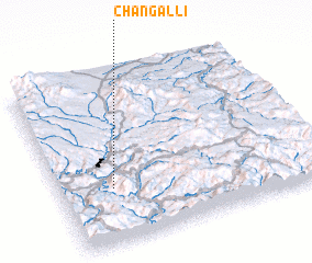 Places with similar names to Changal-li, Korea, North ::
Disclaimer :: Information on this page comes without warranty of any kind |
||
|
Where is Changal-li? Elevation and coordinates ::
Latitude (lat): 41°19'46"N Longitude (lon): 128°12'30"E
Elevation (approx.): 725m (map arrows pan, magnifying glasses zoom) |
||
|
Visiting Changal-li? Hotel/Accommodation ::
Book a hotel in Changal-li Travel Guide ::
rental cars ::
car rental offers GPS waypoint ::
download a GPX waypoint (PoI) of Changal-li for your GPS receiver
|
||