|
search place name
|
||
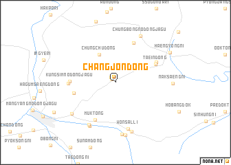
Changjŏn-dong (Hamgyŏng, Korea, North)Changjŏn-dong is a town in the Hamgyŏng region of Korea, North. An overview map of the region around Changjŏn-dong is displayed below.
regional and 3d topo map of Changjŏn-dong, Korea, North ::
Nearby towns ::
Saŭl-li (0.7km north west) //
To-dong (1.0km north west) //
Chungch'u-dong (4.9km north west) //
Muk-tong (6.5km south) //
Sŏŭibong (5.3km west) //
Chungch'u-dong (6.8km north) //
Taein-dong (5.7km north east) //
Naksaeng-ni (5.9km north east) //
Kungsim-nodongjagu (5.5km west) //
Chukp'o-dong (5.7km west) //
Wŏnsal-li (7.7km south) //
Ch'anghyo-ri (7.6km south west) //
Nongsak-kol (7.8km south west) //
Ongnarukaek-kol (8.2km south) //
Uch'onhap'yŏng (8.5km south) //
Chungbong-nodongjagu (8.1km north) //
Se-dong (8.6km south) //
Kŭmsaeng-ni (7.3km south west) //
[all distances 'as the bird flies' and approximate]  Places with similar names to Changjŏn-dong, Korea, North ::
// Changjin-dong (KP)
// Ch'angjŏn-dong (KP)
// Ch'angjŏn-dong (KP)
// Ch'ŏngjŏn-dong (KP)
// Changjŏn-dong (KR)
// Changjŏn-dong (KR)
// Changjŏn-dong (KR)
// Ch'ŏngjŏn-dong (KP)
// Changjin-dong (KP)
Disclaimer :: Information on this page comes without warranty of any kind |
||
|
Where is Changjŏn-dong? Elevation and coordinates ::
Latitude (lat): 42°29'33"N Longitude (lon): 129°51'24"E
Elevation (approx.): 326m (map arrows pan, magnifying glasses zoom) |
||
|
Visiting Changjŏn-dong? Hotel/Accommodation ::
Book a hotel in Changjŏn-dong Travel Guide ::
rental cars ::
car rental offers GPS waypoint ::
download a GPX waypoint (PoI) of Changjŏn-dong for your GPS receiver
|
||