|
search place name
|
||
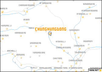
Chunghŭng-dong (Korea, North)Chunghŭng-dong is a town in Korea, North. An overview map of the region around Chunghŭng-dong is displayed below.
regional and 3d topo map of Chunghŭng-dong, Korea, North ::
Chunghŭng-dong airports ::
The nearest airport is FNJ - Pyongyang Intl, located 221.4 km south of Chunghŭng-dong.
Nearby towns ::
Sinhŭng-dong (2.3km north west) //
Hyŏksil-li (4.2km south east) //
Nop'yŏng-dong (4.6km north west) //
Ŭngam-dong (5.6km south west) //
Changjae-dong (6.5km south east) //
Sŏngjo-dong (6.7km south west) //
Yongp'o-dong (8.0km south west) //
Sinsŏng-ni (6.7km east) //
Changhang-dong (7.8km south east) //
Inam-ni (8.3km north west) //
Ssangsil-li (9.7km south west) //
[all distances 'as the bird flies' and approximate] 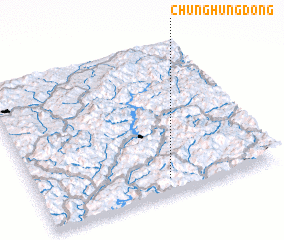 Places with similar names to Chunghŭng-dong, Korea, North ::
// Changhang-dong (KP)
// Changhang-dong (KP)
// Changhang-dong (KP)
// Changhang-dong (KP)
// Changhang-dong (KP)
// Changhang-dong (KP)
// Changhang-dong (KP)
// Changhŭng-dong (KP)
// Changhŭng-dong (KP)
// Chinŭng-dong (KP)
Disclaimer :: Information on this page comes without warranty of any kind |
||
|
Where is Chunghŭng-dong? Elevation and coordinates ::
Latitude (lat): 41°6'0"N Longitude (lon): 126°33'0"E
Elevation (approx.): 642m (map arrows pan, magnifying glasses zoom) |
||
|
Visiting Chunghŭng-dong? Hotel/Accommodation ::
Book a hotel in Chunghŭng-dong Travel Guide ::
rental cars ::
car rental offers GPS waypoint ::
download a GPX waypoint (PoI) of Chunghŭng-dong for your GPS receiver
|
||