|
search place name
|
||
Chungyang-ni (Kangwŏn, Korea, North)Chungyang-ni is a town in the Kangwŏn region of Korea, North. An overview map of the region around Chungyang-ni is displayed below.
regional and 3d topo map of Chungyang-ni, Korea, North ::

Chungyang-ni airports ::
The nearest airport is FNJ - Pyongyang Intl, located 135.5 km west of Chungyang-ni.
Other airports nearby include SHO - Sokch'o Sokcho (177.7 km south east), GMP - Seoul Gimpo (201.0 km south), SSN - Seoul East Seoul Ab (209.9 km south), KAG - Kangnung Gangneung (230.3 km south east), Nearby towns ::
Sŏktari (0.5km north west) //
Yongdam-nodongjagu (1.1km north) //
Tŏksang-ni (0.9km west) //
Tŏk-kol (1.1km west) //
Samnae (1.8km north) //
Munwang-ni (1.4km west) //
Kombaesan (1.7km north west) //
Yangsirang-ni (1.7km east) //
Kurak (1.9km west) //
Yulchae (1.9km west) //
Sinp'ung-ni (2.2km south east) //
Naeoryu-gol (2.6km north east) //
Tŏngnyŏng-ni (2.3km east) //
Changp'ung-ni (2.5km north east) //
Hakp'o-ri (3.2km north) //
Sinhŭng-ni (3.3km north) //
Oryu-gol (3.7km north) //
Changhŭng-ni (3.2km north east) //
Tojang-gol (3.3km north west) //
Tunjŏn (4.0km north) //
Sumunmegi (4.0km north) //
Yongdang-ni (3.4km north west) //
P'iga-ri (3.8km south east) //
Ch'ŏnnae-ŭp (4.0km north west) //
Inhŭng-ni (4.0km south west) //
Tŏng-mal (4.6km north) //
Songjung-ni (3.8km east) //
Sinch'ang-ni (4.7km south east) //
Sae-mal (4.8km south west) //
[all distances 'as the bird flies' and approximate] 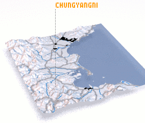 Places with similar names to Chungyang-ni, Korea, North ::
// Changyang-ni (KP)
// Chungyang-ni (KP)
// Chungyang-ni (KP)
// Chungyang-ni (KP)
// Chungyŏng-ni (KP)
// Changyang-ni (KR)
// Changyang-ni (KR)
// Chŏngyang-ni (KR)
// Ch'ŏngyongan (KR)
// Ch'ŏngyong-ni (KP)
Disclaimer :: Information on this page comes without warranty of any kind |
||
|
Where is Chungyang-ni? Elevation and coordinates ::
Latitude (lat): 39°20'5"N Longitude (lon): 127°14'2"E
Elevation (approx.): 35m (map arrows pan, magnifying glasses zoom) |
||
|
Visiting Chungyang-ni? Hotel/Accommodation ::
Book a hotel in Chungyang-ni Travel Guide ::
rental cars ::
car rental offers GPS waypoint ::
download a GPX waypoint (PoI) of Chungyang-ni for your GPS receiver
|
||